Huw S. Groucutt
Department of Classics and Archaeology, University of Malta, Msida, Malta
When people think of archaeology, they often imagine things like ancient temples, or objects such as pots and stone tools. Why certain special sites and iconic objects should dominate the scholarly and public imagination is understandable. However, the archaeological record can also be seen from another perspective: the cumulative way in which humans have shaped and modified the planet. This is not only an intrinsically fascinating topic, but given the current joint climate and biodiversity crisis, it is essential. For instance, when we think about the impacts of climate change, such as droughts and storms, these are filtered through and modulated by the highly anthropogenic landscapes which humans have created over much of the planet. Ultimately, our planet is an artefact that we need to study.
One obvious example that illustrates these themes is urbanization. The kinds of impermeable surfaces that dominate cities have dramatic impacts on hydrological processes, and often lead to increased flood risks. Yet, cities only became widespread in the very recent past. Other processes have much deeper roots. Processes of landscape modification (such as extensive deforestation) been going on for thousands of years, with dramatic impacts in terms of soil erosion, ecological diversity, and much more. Indeed, it has been argued that such processes are at the root of current global warming (Ruddiman et al., 2020). While the Anthropocene—the age in which humans dominate earth systems—is sometimes argued to have a recent origin in the 19th or 20th centuries, it is clear that humans have been modifying the planet with profound impacts for thousands of years (e.g. Boivin et al., 2016).
One of the most significant ways in which humans have shaped the planet is agricultural terracing (see e.g. Wei et al., 2016; Brown et al., 2021). This consists of the modification of sloping land into flatter areas for agricultural use separated by walls or banks. Most people in the world rely on terraced agriculture for their subsistence, and terracing has sweeping impacts in terms of limiting soil erosion, aiding water retention, and much else besides. Despite this profound importance, there is currently little knowledge or agreement on when, where, and why terracing began, on its impacts, and how it has changed over time. In recent decades, another factor enters the equation, which is that in areas such as the Mediterranean vast areas of terracing has been abandoned in the last few decades. This means in many cases terraces are now collapsing and eroding. This creates potential food security problems, as well as leading to rapid soil erosion, and increasing the risk of flooding, as well as the physical danger of collapses and landslides. There is little knowledge on even basic aspects such as the land area which has been terraced in the past. To give an illustrative example, in China terracing covers significantly more than cities do (more than 6% versus less than 1%) (Cao et al., 2020; Liu et al., 2021). In the case of some Mediterranean islands, more than 30% of the land is terraced (Bevan et al., 2013).
Until recently, terraces were given relatively little scholarly attention, perhaps because they were seen as rather mundane, and also challenging to accurately date. That picture has begun to change as the importance of terracing has become both increasingly clear and recognized, and as methods have developed which aid their detailed study. Several terraced landscapes are now UNESCO World Heritage Sites, such as Battir in Palestine. Terracing as a component of sustainable agriculture is now widely discussed (Deng et al., 2021; Kinnaird et al., 2025). Methods such as optically stimulated luminescence dating are increasingly being used to study terraces histories (e.g. Srivastava et al., 2023), as are increasingly detailed methods of spatial analysis (e.g. Cucchiaro et al., 2021). Work on terraces in recent years has begun to bring valuable empirical data and the theoretical developments (e.g. Bevan et al., 2013; Turner et al., 2018; Brown et a., 2021; Chen et al., 2024).
These theoretical and methodological developments allow fundamental questions on terracing and its impacts to be addressed. For example, why did people begin terracing in the first place? Was it to limit soil erosion, or, rather to bring new areas into cultivation by building walls and importing soil? What kind of social, political, and technological circumstances lead to the emergence of terracing? For instance, it often seems to be in the context of hierarchical societies and empire, be they Ottoman or Inca (e.g. Kosiba, 2018; Elgart-Sharon et al., 2020), yet other evidence indicates that terracing can develop at the scale of household-labour and in the context of resistance (e.g. Acabado, 2018). While terraces rapidly collapse if not maintained, what factors (e.g., age, geology, construction methods, wall height and/or climatic conditions) contribute to this process? Exploring such questions means elucidating terrace histories over time and space, and contextualizing the evolution of terracing in social, ecological, and climatic context.
A European Research Council (ERC)-funded project lead by the author under the name TerraForm has just been launched. The five-year project explores the origin, evolution, and impacts of agricultural terracing. TerraForm uses the Maltese Islands as a model system to explore terracing and its impacts. See Figure 36. This choice is due to a number of factors. Firstly, Malta is intensively terraced, with stepped slopes shaped by an abundance of humanly made banks and stone walls (typically called ‘rubble walls’ in Malta; Ħitan tas-Sejjieħ in Maltese). See Figures 37 and 38. Secondly, there are signs that Malta featured early, prehistoric, terracing and then multiple cycles of terrace construction and decay. Malta is small and isolated, is geologically young, and its climate alternates between dominant aridity and occasional intense storms, there has been limited time for soil to form (and much of what does form is rapidly eroded). Social aspects are also key. As an archipelago with outstanding harbours located at the very centre of the Mediterranean, Malta has long been fought over by different colonial powers. This proto-global role catalysed a population boom, meaning that today Malta is one of the most urbanised and densely populated (>1500 people per km2) countries in the world. Malta’s small size and its climatically and culturally turbulent past also mean that it has seen major socio-political turnovers, and perhaps entire population hiatuses, again creating conditions for repeated terrace construction and decay. The logic on which TerraForm is based suggests that these particular geographical, climatic, and social characteristics have led to unusually intensive terracing in Malta, which can therefore help cast light on terracing more broadly.
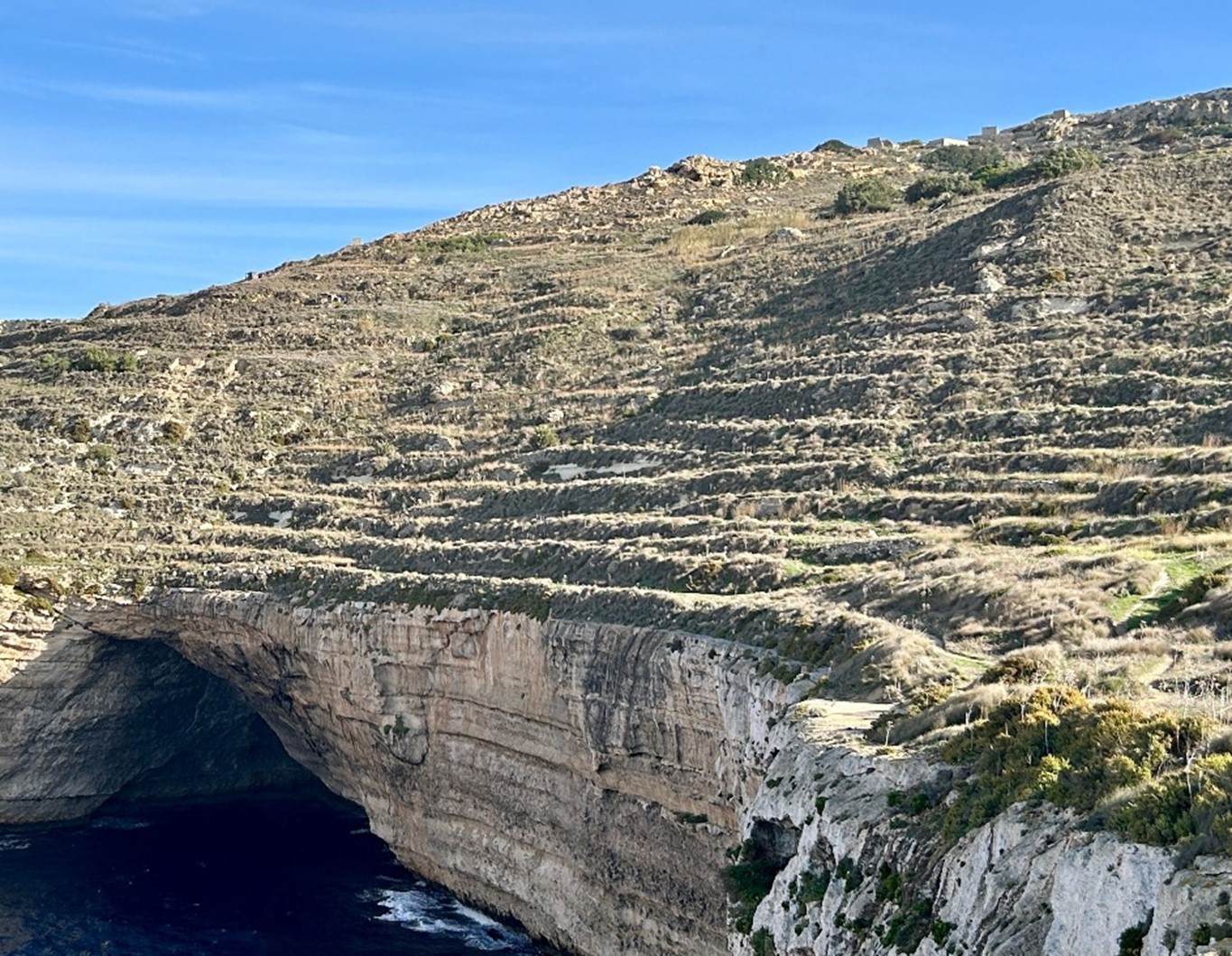
Figure 36. A highly terraced hillside above a fifty-metre-high sea cliff and cave (Għar id-Dwieb), close to Ras id-Dawwara, Malta. Note that these agricultural terraces are no longer in use. Photo by Huw Groucutt.
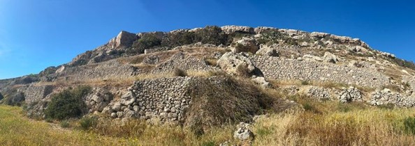
Figure 37. A highly terraced hillside at Qammieh, northwest Malta. Photo by Huw Groucutt.
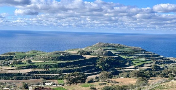
Figure 38. The Il-Gwiedi/Ta' Hammud area of western Malta showing intense terracing. Photo by Huw Groucutt.
TerraForm will bring together various researchers from Malta and elsewhere to study terracing. This will include many researchers the University of Malta, as well as two project co-investigators: Prof. Andrea Zerboni (University of Milan), who will study sedimentology and geochemistry, and Dr Eric Andrieux (University of Durham), who will conduct optically stimulated luminescence dating. TerraForm will explore a series of hypotheses on terracing and its impacts through a highly multidisciplinary framework. Temporal information will come from multiple archaeological excavations of terraced sites. Spatial perspectives will be explored at a variety of scales, from individual sites through to island wide spatial analyses of terracing in a Geographical Information System framework. Soil sequences will cast light on geochemical, sedimentary, and ecological changes associated with terracing, and high-resolution studies will be performed on a variety of archives to cast light on the climatic context. Archives of historical maps and documents will be studied to explore the written, drawn, painted, and photographic record relating to terracing. Ecological succession will be recorded on terraces which have been abandoned at different times. Finally, we will discuss the terraced landscape with farmers and others who use the terraces today.
Malta is famous for its history and archaeology. Highlights include its spectacular early modern fortified cities, built during the long struggle of the Maltese and the Knights of Saint John against the Ottoman Empire, through to the numerous Neolithic ‘temples’ which are some of the oldest large-scale buildings on the planet. The country has the greatest density of UNESCO world heritage sites in the world by area. Though its terraced landscapes have long been recognised, they have received much less scholarly attention. There is currently little knowledge on the history of terracing in Malta (but see Saliba, 2008; Bennett, 2020). It has often been stated that terracing began, or at least proliferated, in the Islamic period, focussed on the 10th and 11th centuries AD. Specific evidence for this is, however, limited. It is also clear that much of the terracing in its final form dates from recent centuries.
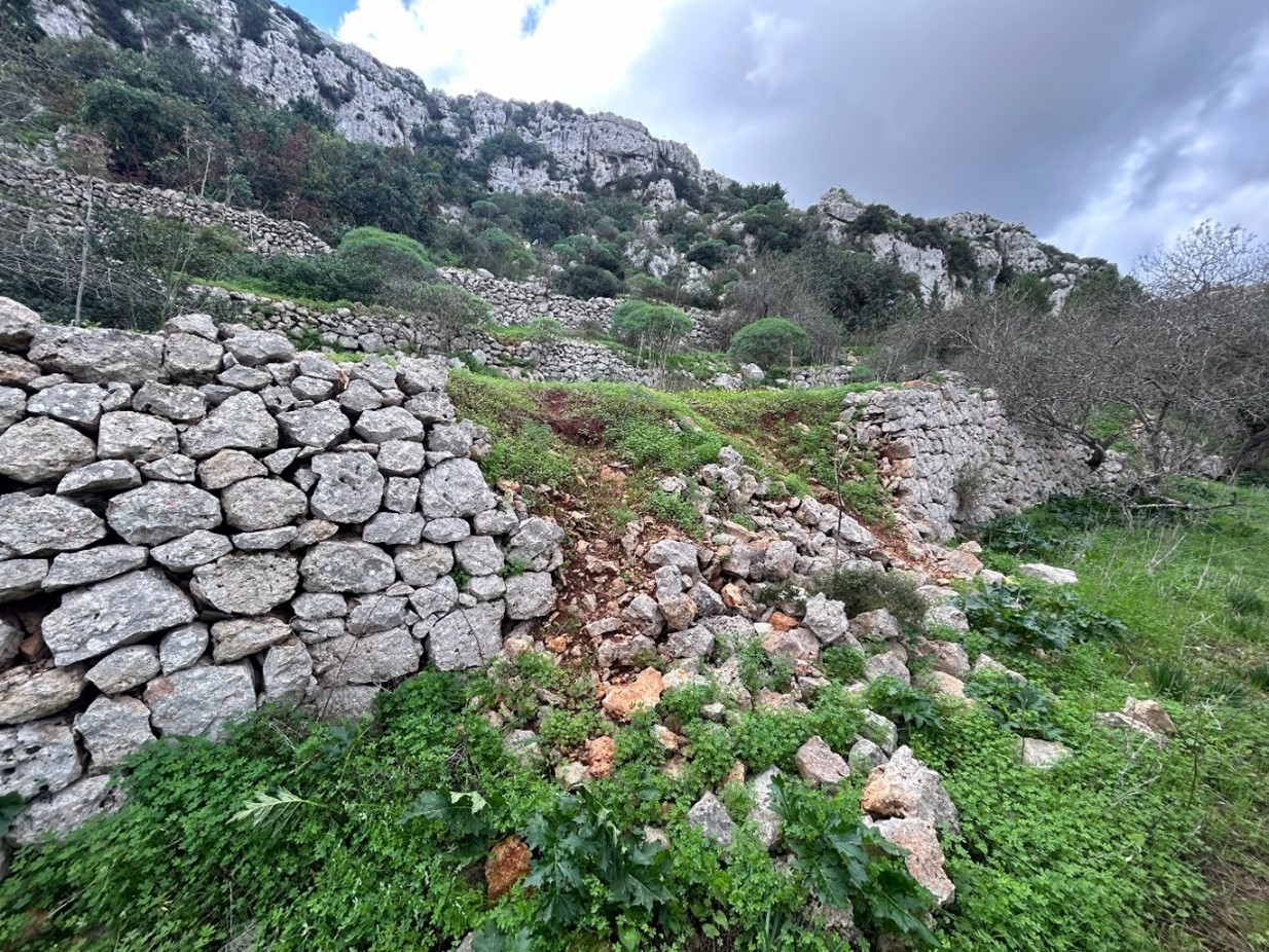
Figure 39. Collapse in terrace wall, Wied il-Għasel, Malta. Photo by Huw Groucutt.
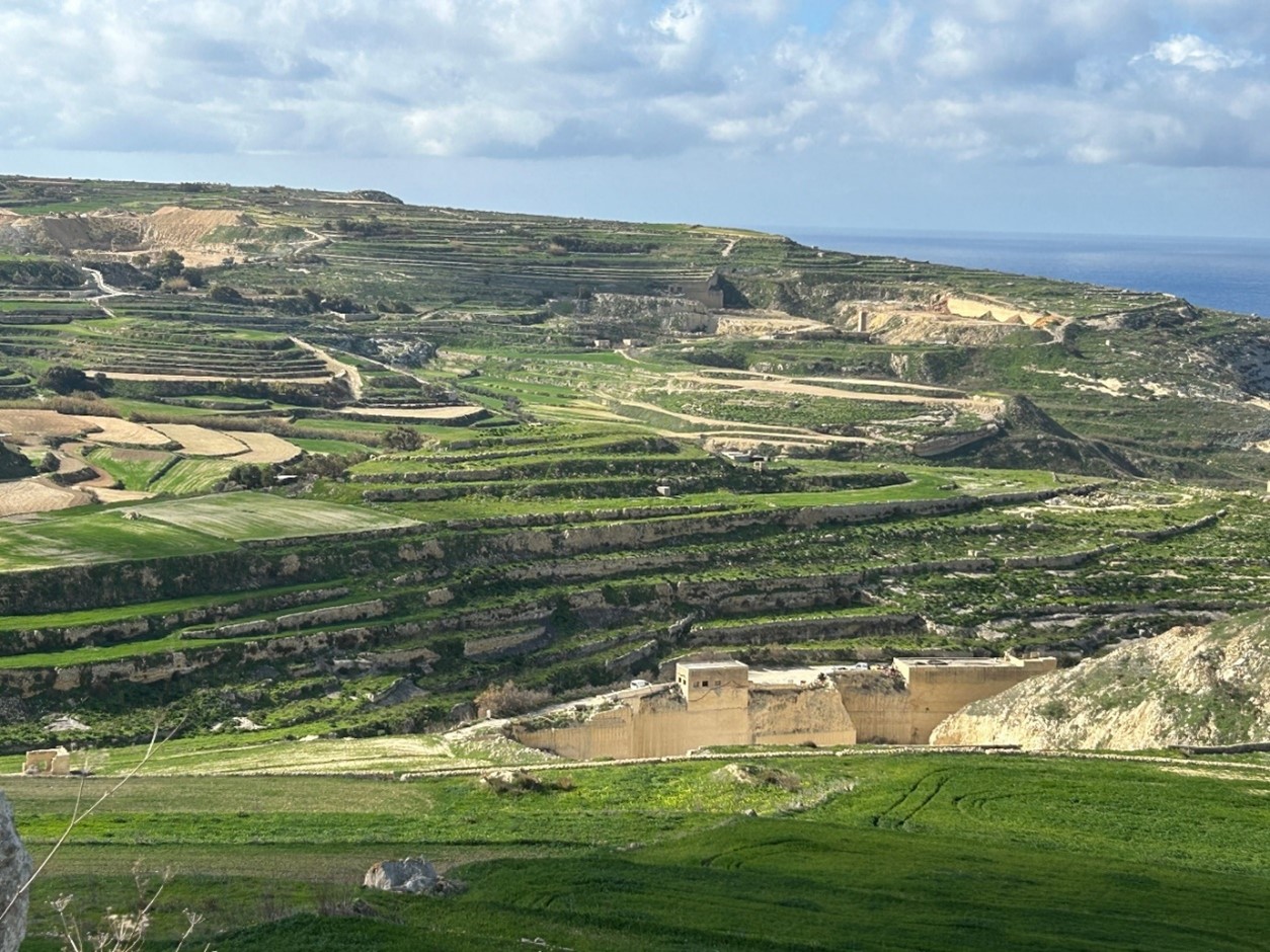
Figure 40. Several stone quarries in the highly terraced landscape of western Gozo. Photo by Huw Groucutt.
There is some evidence for terracing extending back to at least the Phoenician period (Pace 2004). Indirect hints suggest that terracing may have much earlier foundations in Malta. Key here is the recent suggestion that terracing in Malta began in the Bronze Age based on indirect evidence in terms of an apparent significant reduction in soil erosion at this time recorded in valley bottom sediment sequences (Hunt et al., 2020). While quite possible, the substantiation of this argument requires both direct on-site evidence and climate data, as, for instance, changing rainfall can also have had a profound impact on erosion. Currently the main source of ecological data comes from pollen sequences, (e.g. Farrell et al., 2020), yet these are impacted by many biases and reflect a combination of climate and human land use changes. Data from molluscs hints at significant climate change over time in Malta (Fenech et al., 2020). TerraForm aims to both elucidate terracing and to situate this within an appropriate high-resolution palaeoclimatic context.
There have also been suggestions that terracing in Malta extends back to the Neolithic (e.g. Zammit, 1928; Pace, 2022). This primarily comes indirectly from the fact that the so-called Temple Period (Late Neolithic) demonstrates a high level of technological and social complexity. Around thirty or so megalithic ‘temples’ are found in the islands, and terracing architectural purposes (i.e. temple construction) is clear. Given this, is it possible that this society also engaged in agricultural terracing? Even if they did not, the reasons behind such a choice would be fascinating to consider. Malta’s Temple Period saw a long-lived society, with an evidently relatively large population occupying a remote and climatically unstable area, so methods such as terracing would surely have aided such societies. Hints from sites such as Skorba and Ġgantija may reflect early terracing. For instance, at Ġgantija a fifty-metre-long wall was built directly in front of the temples. This has been described as having possibly created “the first recognizable agricultural soil” in Malta (French and Taylor, 2020, p. 182). Alternatively, the construction may somehow relate to ritual temple use.
Today, there is discussion of the challenges facing the terraced landscape today (e.g. Rolé, 2007; Cyffka and Bock, 2009). The widespread abandonment of agriculture since the 1960s means that in many places terraces are decaying. See Figure 39. Discussions about the best policies for the future can aided by scientific data on the evolution of Malta’s terraced landscapes, as well as by discussion with those who use these landscapes today.
TerraForm aims to carry out the most intensive study of a terraced landscape ever conducted. The multiple excavations will cast light on the origins and evolution and terracing. Through methods such as micromorphology, optically stimulated luminescence (OSL) dating, and high-resolution spatial analyses, we aim to characterise Malta’s terraced landscape as it exists today, and to extend back in time to understand how it has began and changed. TerraForm highlights the way that diverse disciplines can work together with archaeology to cast light on the history of the highly anthropogenic landscapes which characterise much of the planet.
The coming years will see some exciting findings on the evolution of terraced landscapes in Malta, which it is hoped can also contribute to building a more sustainable future (see e.g. Boivin and Crowther, 2021; Kinnaird et al., 2025). The terraced landscapes of Malta are found in a country and region facing climatic and social challenges, with the central Mediterranean identified as a climate change hotspot. Vast swathes of the terraced landscape have been recently covered by urbanisation, while other processes such as quarrying have also had a large impact. See Figure 40. Elucidating terracing highlights one way in which archaeology can contribute to learning from the past to improve our future.
Bibliography
- Acabado, S. (2018). “Zones of refuge: Resisting conquest in the northern Philippine highlands through environmental practice” Journal of Anthropological Archaeology 52, 180-195.
- Boivin, N., et al., (2016), “Ecological consequences of human niche construction: Examining long-term anthropogenic shaping of global species distributions”. Proceedings of the National Academy of Sciences USA 113, 6388-6396.
- Boivin, N., Crowther, A. (2021). “Mobilizing the past to shape a better Anthropocene”. Nature Ecology and Evolution 5, 273-284.
- Bennett, J. (2020). “Testing terraces: Managing and sustaining the agrarian environment in the Maltese archipelago”. Unpublished PhD thesis, University of Cambridge.
- Bevan, A., et al. (2013). “The Long-Term Ecology of Agricultural Terraces and Enclosed Fields from Antikythera, Greece” Human Ecology 41, 255-272.
- Brown, A.G., et al. (2021). “Ending the Cinderella status of terraces and lynchets in Europe: The geomorphology of agricultural terraces and implications for ecosystem services and climate adaptation” Geomorphology 379, 107579.
- Cao, B. et al., “A 30 m terrace mapping in China using Landsat 8 imagery and digital elevation model based on the Google Earth Engine”. Earth System Science Data 13, 2437-2456.
- Chen, L., et al. (2024). “Long-term terrace change and ecosystem service response in an inland mountain province of China”. Catena 234, 107586.
- Cucchiaro, S., et al. (2021). “Volume estimation of soil stored in agricultural terrace systems: A geomorphometric approach” Catena 207, 105687.
- Cyffka, B., Bock, M. (2009). “Degradation of field terraces in the Maltese islands – Reasons, processes and effects” Geografia Fisica e Dinamica Quaternariasia 31, 119-129.
- Deng, C., et al. (2021). “Advantages and disadvantages of terracing: A comprehensive review” International Soil and Water Conservation Research 9, 344-359.
- Elgart-Sharon, Y., Porat, N., Gadot, Y. (2020). “Land management and the construction of terraces for Dry Farming: The case of Soreq catchment, Israel”. Oxford Journal of Archaeology 39, 374-289.
- Farrell, M., Hunt, C.O., McClung, L.C. (2020). “The Holocene vegetation history of the Maltese islands”, in French, C., et al. (eds) Temple Landscapes. Facility, change and resilience of Holocene environments in the Maltese Islands, McDonald Institute for Archaeological Research, Cambridge, pp.73-114.
- Fenech, K., et al. (2020). “Molluscan remains from the valley cores”, in French, C., et al. (eds) Temple Landscapes. Facility, change and resilience of Holocene environments in the Maltese Islands, McDonald Institute for Archaeological Research, Cambridge, pp.115-159.
- French, C., Taylor, S. (2020). “The geoarchaeology and micromorphology of past landscape sequences on Gozo and Malta”, in French, C., et al. (eds) Temple Landscapes. Facility, change and resilience of Holocene environments in the Maltese Islands, McDonald Institute for Archaeological Research, Cambridge, pp. 161-222.
- Hunt, C., et al. (2020). “Chronology and stratigraphy of the valley systems”, in French, C., et al. (eds) Temple Landscapes. Facility, change and resilience of Holocene environments in the Maltese Islands, McDonald Institute for Archaeological Research, Cambridge, pp.35-72.
- Kinnard, KC., et al. (2025). “Unearthing the histories of Agrarian landscapes: A research framework for terraces as sustainable environments. Geoarchaeology 40:e70004.
- Kosiba, S. (2018). “Cultivating Empire: Inka Intensive Agricultural Strategies”, in Alconini S. and Covey, A. (eds) Oxford Handbook of the Incas, Oxford University Press, Oxford, pp. 227-246.
- Pace, A. (2004). “Malta during prehistory: an overview”, in Gambin, K. (ed), The Development of Malta from an Island People to an Island Nation, Midsea, Malta, pp. 25-44.
- Pace, A. (2022), “The development of Late Neolithic burial places in Malta and Gozo: an overview” in Stoddart, S., et al. (eds), Temple people. Bioarchaeology, resilience and culture in prehistoric Malta, McDonald Institute for Archaeological Research, Cambridge, pp.333-354.
- Rolè, A. (2007). “The terraced landscapes of the Maltese islands”, in Pedroli, B., van Doorn, A., de Blust, G. (eds), Europe’s Living Landscapes, KNNV, Holland, pp. 405-420.
- Ruddiman, W.F., He, F., Vavrus, S.J., Kutzbach, J.E. (2020). “The early anthropogenic hypothesis: A review” Quaternary Science Reviews 240, 106386.
- Saliba, P.C. (2008), “An evaluation of rubble walls and terracing in the Maltese landscape”. Unpublished Masters thesis. University of Malta.
- Srivastava, A., et al. (2023). “Dating agricultural terraces in the Mediterranean using Luminescence: Recent Progress and Challenges” Land 12, 716.
- Turner, S., et al. (2018). “Agricultural terraces in the Mediterranean: Medieval intensification revealed by OSL profiling and dating” Antiquity 95, 773-790.
- Wei, W., et al. (2016). “Global synthesis of the classifications, distribution, benefits and issues of terracing” Earth Science Reviews 159, 388-403.
- Zammit, T. (1928). “Prehistoric cart-tracks in Malta” Antiquity 11, 18-125.
Go back to top