Itiner-e: a linked open gazetteer of ancient roads

Tom Brughmans1, Pau de Soto2 and Adam Pažout2

1Social Resilience Lab, Aarhus University

2Departament de Ciències de l'Antiguitat i de l'Edat Mitjana, Universitat Autònoma de Barcelona

In November 2025 we published a data paper in Scientific Data (de Soto et al. 2025) that launched Itiner-e.org19: the first spatially detailed linked open gazetteer of roads of the Roman Empire. See Figure 1. It is the result of aggregating and digitizing published information about the location of Roman roads by a team of twenty scholars from across Europe and Turkey. Here we briefly summarise our approach and key findings; we discuss the gaps in our knowledge revealed by this work, and we argue that the future of this resource should be driven by a community.


Figure 1. Map of Roman roads contained in Itiner-e.org. Image © Itiner-e.org.

Digitizing Roman roads

The topic of roads in the Roman Empire is one of the most iconic research areas in Roman studies, which encompass the structure and functioning of a network that affected the lives and mobility of millions, and spanned more than 30 modern countries across Europe, the Middle East and North Africa. The efforts by archaeologists, historians and passionate local communities from all these countries makes the study of Roman roads a particularly diverse field. Moreover, it is rather rich in exceptional sources, including: lists of stations and distances through the ancient world like the Antonine Itineraries, enigmatic material sources like the Vicarello cups or the Tabula Peutingeriana, thousands of milestones pinpointing locations with inscriptions describing major infrastructure investments, countless excavations in cities throughout the region, and surveys mapping entire landscapes. Nevertheless a spatially-detailed integration of the data from these sources regarding the locations of the Roman roads was missing.

Our team aimed to provide this missing resource in order to create a better understanding of the variability in our knowledge of the location of Roman roads. We conceived of this project as the aggregation and digitization of an extensive trove of published evidence, since no field research could cover such a vast area as that represented by the Roman Empire. However, we considered it necessary to first create a more detailed map of roads as a basis for informing future archaeological efforts to improve it.

The method consisted of road identification, followed by localization and then digitization. The approach was affected by regional methodological diversity given the variability of sources and collaborators in this vast research area (see ‘Regional overviews’ in de Soto et al. 2025). Past scholarship and historical sources guided the first phase of road identification. This concerned determining whether or not a road had actually connected two places at some point during the Roman period. We relied on existing atlases and regional compilations, surveys, milestone data and archaeological excavations. See Figure 2. Particularly valuable were the Barrington Atlas of the Greek and Roman World (Talbert 2000), Tabula Imperii Romani and Tabula Imperii Byzantini. The Barrington Atlas was a mammoth undertaking by a large scholarly community to map the places and roads of the ancient world. Over the 25 years since its publication, it has stimulated and informed vast amounts of research within Roman studies. The Barrington Atlas formed the foundation of pioneering digital resources such as the Pleiades linked open data gazetteer of ancient places, and the digitizations of roads by the Ancient World Mapping Centre and Mapping Past Societies.

While the Barrington Atlas was foundational as a resource, it also clarified where a new resource could make a valuable contribution. The Barrington Atlas includes the major roads that are well documented through itineraries and milestones. Although it also includes many secondary roads, this is done less uniformly and comprehensively throughout the empire. Moreover, the resolution of this atlas is either 1:1,000,000 or 1:500,000, meaning it was not designed to reflect roads that respect topography in high spatial detail. Our road identification work aimed in particular at including research that was either published in the 25 years since the publication of the Barrington Atlas, or otherwise omitted from it as well as published evidence of secondary roads. The latter includes country lanes, farm tracks and private roads. So far, the dataset does not include city streets, an obvious target for future growth.


Figure 2. Example of the source material for the road identification phase. (Above) detail of a map sheet of the Tabula Imperii Romani: Iudaea/Palaestina showing Roman sites and roads. (Below) detail of a map sheet 17 of the Survey of Western Palestine identifying a Roman road.

The second phase aimed to locate the roads thusly identified within the landscape. This was done by comparing published information about locations with diverse remote sensing and mapping sources, including aerial photography and modern and historical topographic maps and satellite imagery. See Figure 3. Particularly valuable was the existence of open digital datasets providing the location of tens of thousands of ancient places (Pleiades) and over eight thousand milestones (Heřmánková et al. 2021). The spatial location of these sources was carefully checked and corrected and served as anchor points for the localization. This was followed by a third phase of manually digitizing the course of each road section informed by the localization. We aimed for a target resolution of 5-200 m, to obtain a data representation that respected the variability of the topography.


Figure 3. Modern satellite imagery (© Esri) showing caravan tracks in Egypt’s Western Desert on a route from Kharga Oasis to the Nile Valley, which has probably been in use since the Old Kingdom period.

Mapping data confidence

This process resulted in adding more roads at higher spatial resolution than previous Empire-wide aggregations. The database includes a total length of 299,171 km of roads (which is an increase of more than 100,000 km in comparison to the total length as reflected in the Barrington Atlas). But this major finding was also paired with a sobering realisation: the location of only 2.7% of this total road length is known with certainty. How can it be that we created a spatially detailed atlas where 97% of locations are uncertain?

It is crucial to emphasise that it is the precise location (rather than the identification that there was, in fact a road) that is uncertain, and Itiner-e is the first resource that enables the identification of this uncertainty. This is highly valuable as it enables targeting future work more precisely and evaluating the impact of uncertain knowledge on analytical results through sensitivity analyses. Moreover, this spatially detailed resource results in a road length estimate that is more reliable than digitization at a very coarse resolution that does not reflect topography. However, we argue it is crucial to be highly explicit about what we do not know, since we consider Itiner-e a growing resource (see discussion below). In this section we describe this locational uncertainty, and the ways in which Itiner-e’s data structure allows us to capture variability in our knowledge about Roman roads.

We specified location certainty using three categories: certain, conjectured, and hypothetical. We consider road locations certain if they could be identified within 50 m in mountainous areas and within 200 m in flatlands. The vast majority of road locations (89.8%) are considered informed conjecture: these are identified Roman roads for which we know the location at a resolution coarser than 200 m. The remaining 7.3% concerns hypothetical roads, which refer to roads whose existence or location is hypothesised rather than known. This category is mostly used for desert tracks where the precise path is not necessarily marked by traces of infrastructure and multiple routes might have connected the same places.

The 2.7% certain road locations reflect about 8,000 km of roads. Most of these roads are still visible in the terrain in the form of paved sections or land divisions. See Figure 4. We can expect this number to grow slightly over time as Itiner-e will increasingly include more data with higher spatial accuracy from new excavations and/or surveys. However, the 2.7% proportion will likely decrease since roads are heritage features that are highly threatened by continued use, and long linear features are unlikely to ever be excavated at scale. By contrast, we can also expect higher increases in the other two types of road certainty categories: conjectured and hypothetical. Our new dataset reveals that there are hundreds of known landlocked places throughout the Roman Empire that were not connected, but which must have been reachable in some form or other.


Figure 4. A section of the Via Nova Traiana in Jordan. Image © Adam Pažout, with permission.

These findings reveal the need to document and visualise the variability in our confidence in the dataset. See Figure 5. This was done through a confidence map which expresses three aspects of the data, for each 0.5*0.5 degree (latitude * longitude) cell in this nearly 4,000,000 km2 area: (1) the degree to which the coverage is representative expressed as the road density, (2) the degree to which the spatial resolution is representative expressed as vertex density, and (3) the degree to which we considered the sources to which we had access as reliable. In addition to the confidence map, we have the locational certainty categories previously mentioned and the observed discrepancy between road and site densities, together making for a rich description of our confidence.


Figure 5. Confidence map of the Itiner-e dataset. Image © Adam Pažout; de Soto et al. 2025, Fig. 6c. (CC-BY-4.0).

A further challenge is the temporal uncertainty in the dataset, which has been revealed as a critical issue for the field of Roman roads studies in general. Comparable temporal information at an Empire-wide scale that allows creating snapshots of the road network per century does not currently exist. We certainly have temporal information on roads (i.e., from the many excavations of segments, milestones and literary sources), but this is only available for a fraction of the 300,000 km of roads so far identified. Moreover, roads tend to be reused. The temporal information we have access to often only reflects one or few phases of a road’s use-life. The Romans occupied areas with existing road systems, which were incorporated and connected into the Roman imperial system. Those roads were sometimes refurbished, and often continued to be used beyond Roman times if the settlements they connected continued to be occupied. Our efforts focused on creating a picture of the state of roads dated between 300 BCE and 400 CE within the area defined by the boundaries of the Roman Empire in ca. 150 CE (excluding the temporary gains by the emperor Trajan). Refining the temporal resolution within this period at an empire-wide scale is a major challenge for the field.

A community-driven growing resource

Our aim with showcasing this variability in confidence was transparency and accountability. A line in an atlas conveys a false sense of certainty that in most cases is not entirely supported by evidence. We wanted to document this explicitly and thereby enable a community of contributors to do the same, such that our confidence in the data could grow as the dataset itself grows. That is also why it is crucial for our data structure to capture pieces of information about each road segment that enables replication and accountability (including the author who did the digitization) and the sources on which said digitalization was based. This structure enables the dataset to reflect a multiplicity of opinions in case observations are ambiguous or insufficient, and/or to enhance existing digitizations with new sources and shared authorship.

Itiner-e will be most valuable if it is carried by a community and explicitly linked in the growing constellation of open digital resources. This is where the next phase of Itiner-e is focussing. Our platform already has the tools built in to allow contributors to register and upload new data, supported by tutorials that explain how to do this, all the while also enabling editors to review the new contributions. Moreover, Itiner-e is already linked to Pleiades, the linked open gazetteer of ancient places, through which it is linked to numismatics and epigraphic gazetteers. We will build on this with regular workshops and more elaborate educational materials, to foster a wider community of contributors. The ultimate aim is for Itiner-e to remain a reliable place to check on our current and ever-increasing knowledge of the location of Roman roads. This will be invaluable for the protection of road heritage in this continental scale area, but also to inform predictive modelling and desk-based heritage assessments to inform development work.

Our confidence map further provides very concrete pointers as to where major gains in our knowledge of the location of Roman roads can be expected, which will be valuable for efforts to add more sources to it and for planning future survey and excavation work. We are committed to keeping Itiner-e an open and living resource carried by an international community, such that it can remain a valuable resource.

Bibliography

de Soto, P., Pažout, A., Brughmans, T., Vahlstrup, P. B., Auir, Á., Bongers, T., et al. 2025. Itiner-e: A high-resolution dataset of roads of the Roman Empire. Scientific Data, 12(1), 1731. https://doi.org/10.1038/s41597-025-06140-z

Heřmánková, P., Kaše, V., & Sobotková, A. 2021. LIRE (v1.0.0) [Data set]. Zenodo. https://doi.org/10.5281/zenodo.5074774

Talbert, R.J.A. (ed.) 2000. Barrington Atlas of the Greek and Roman World. Princeton: Princeton University Press.

---

19(accessed 10/12/2025)

Go back to top 

The AlUla Cultural Oasis Project (UCOP): Unraveling the History of Oases in Arabia

Julien Charbonnier and Yasmin Kanhoush

Archaïos

Oases are among the most fascinating and resilient human-made landscapes in the world. Nestled in the heart of arid regions, they have served as settlement points and vital hubs on caravan routes for millennia. These constructed landscapes have enabled sedentary life in desert environments. Despite their importance, our understanding of oases—particularly their spatial organization, evolution, and role in broader social and economic networks—remains limited. The AlUla Cultural Oasis Project (UCOP), conducted between 2019 and 2025, led by Julien Charbonnier and Yasmin Kanhoush aims to fill these gaps by exploring the al-ʿUlā Oasis in northwestern Saudi Arabia. See Figure 25. This project is the first of its kind to study a still-cultivated oasis in Arabia, offering a unique opportunity to understand how these landscapes have evolved over time.

UCOP is a collaborative effort led by Archaïos. It is funded and steered by the French Agency for AlUla Development (AFALULA) on behalf of the Royal Commission for AlUla (RCU). The interdisciplinary project brings together archaeologists, geographers and architects. Fieldwork involved ten seasons of surveys and excavations which took place between 2019 and 2024.

The AlUla Cultural Oasis Project was designed to address two major blind spots in the archaeology of Arabian oases:

  1. While much research has focused on pre-Islamic oases, the Islamic Period (from the 7th century AD onward) remains poorly documented. UCOP seeks to reconstruct the history of al-ʿUlā during this era, particularly from the 13th to the 19th centuries AD, a period known almost exclusively through travelers’ accounts and historical texts.
  2. Previous studies have primarily examined oases through their agricultural and water systems, or as nodes within commercial networks. UCOP shifts the focus to the internal organization of oases, analyzing how land parcels, water distribution networks, domestic architecture, and circulation systems have shaped (and in turn been shaped by) social, economic, and environmental factors.

By adopting a spatial approach, UCOP treats the oasis not just as an agricultural unit but as a dynamic social and historical space. The project aims to document the oasis’s evolution, from its earliest settlements to its modern challenges.


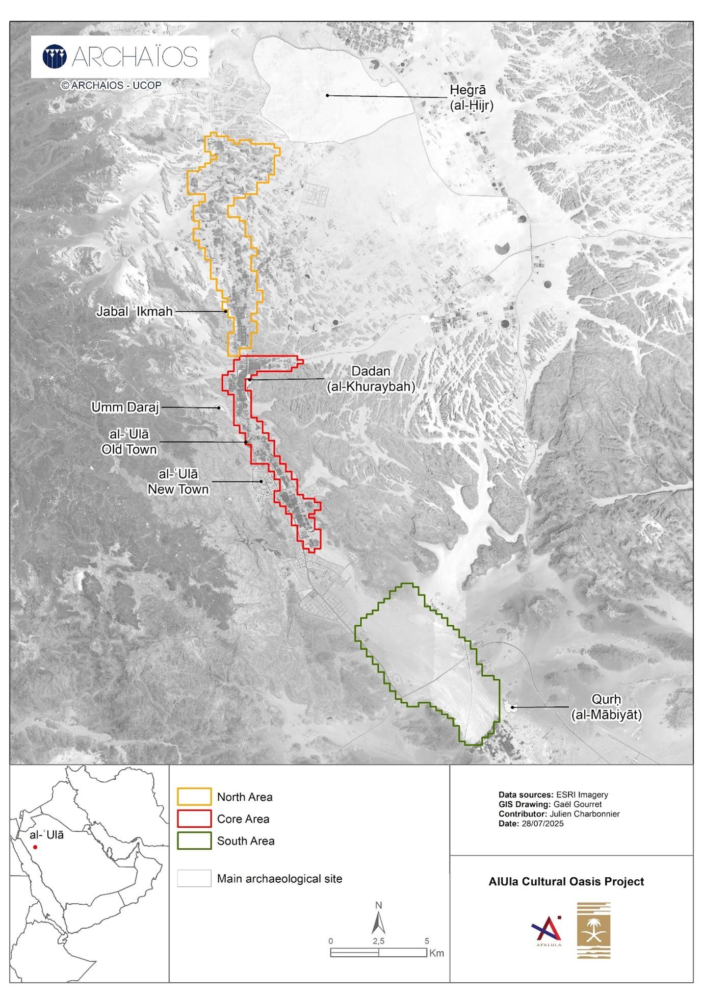
Figure 25. Location of the al-ʿUlā Oasis and project study areas in the valley. Map ©Archaïos.

Study Area: The al-ʿUlā Valley (Saudi Arabia)

The al-ʿUlā Oasis is located in the northern Ḥijāz region of Saudi Arabia, approximately 280 km northwest of Medina and 240 km southeast of Tabuk. The oasis lies in a narrow valley which runs north-south and is surrounded by sandstone escarpments and basaltic plateaus. The valley’s elevation ranges from 650 to 770 meters above sea level. See Figure 26.


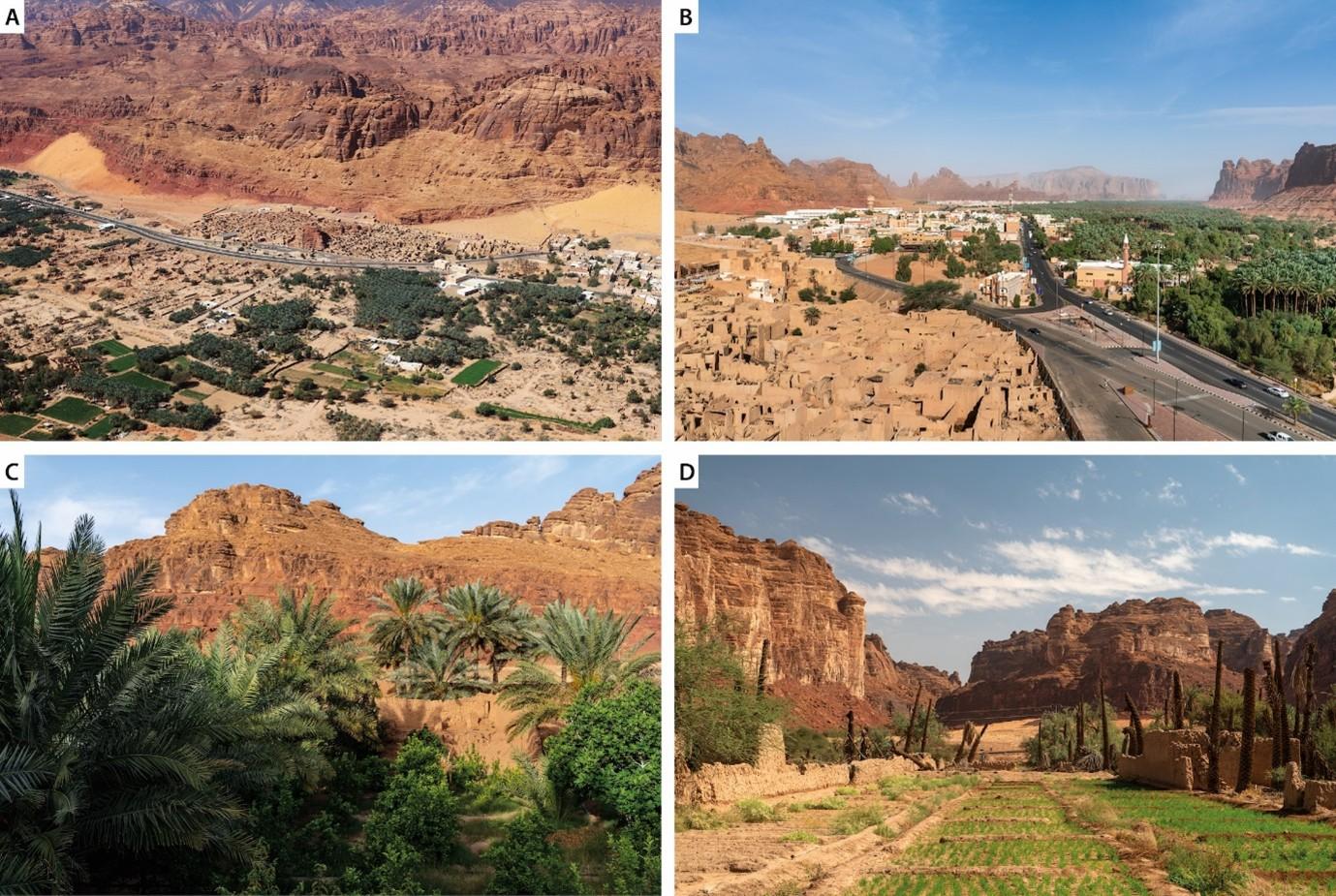
Figure 26. A: The al-ʿUlā Old Town nestled along the cliffs to the west of the valley. Image by J. Charbonnier; B: The palm grove and al-Jadīdah district seen from the Old Town. Image by S. Sepeau; C: Horticultural gardens in the historical core of the palm grove. Image by S. Sepeau; D: Plot returned to cultivation in the historical core of the palm grove. Image by S. Sepeau; ©Archaïos.

The al-ʿUlā Valley has a long history as a crossroads for trade and pilgrimage. It was home to the ancient city of Dadan, a major political and economic center during the 1st millennium BC, and later to Madāʾin Ṣāliḥ (ancient Ḥegrā), which flourished under the Nabataeans. During the Islamic Period, the valley became a key stopover on the Syrian pilgrimage route, connecting the Levant to the holy cities of Mecca and Medina. The Town of al-ʿUlā became the main settlement of the valley after the abandonment of the city of al-Mābiyāt (ancient Qurḥ), during the 12th century AD. Despite its historical significance, the oasis’s internal organization and evolution during the Islamic Period have remained largely unexplored, until now.


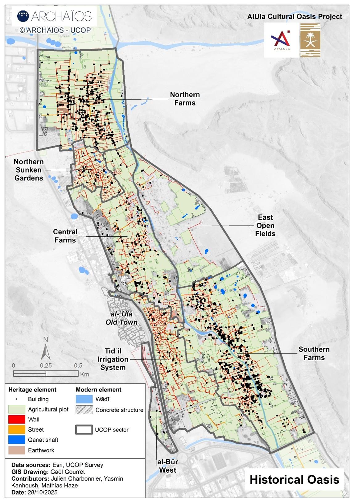
Figure 27. Archaeological map of the central part of al-ʿUlā Oasis (core area of study). Map ©Archaïos.

A Multidisciplinary Approach

UCOP employed a multidisciplinary methodology to document and analyze the al-ʿUlā Oasis:

  • Pedestrian surveys: Systematic fieldwalking was done across 4,000 hectares of cultivated and abandoned agricultural plots to record archaeological structures, heritage features, and to collect material remains. This fieldwork resulted in the creation of the first detailed archaeological map of an oasis in Arabia. See Figure 27.
  • Aerial and satellite imagery: Analysis of archived and modern imagery was used to track changes in the oasis’s landscape over time, particularly since the 1960s.
  • Building archaeology: The project undertook detailed recording of domestic and defensive structures, including perimeter walls, vernacular dwellings (Figure 28), and towers.
  • Water systems: Analysis of water catchment (qanats and wells) as well as irrigation systems inside the palm grove (channels and water distributors) was also made.
  • Material culture analysis: Studies of ceramics, glass, and tobacco pipes were undertaken to better understand trade networks, economic activities, and cultural exchanges.
  • Spatial analysis: Survey data was integrated into a geodatabase to analyze parcel morphology, circulation networks and the distribution of artefacts across the palm grove.


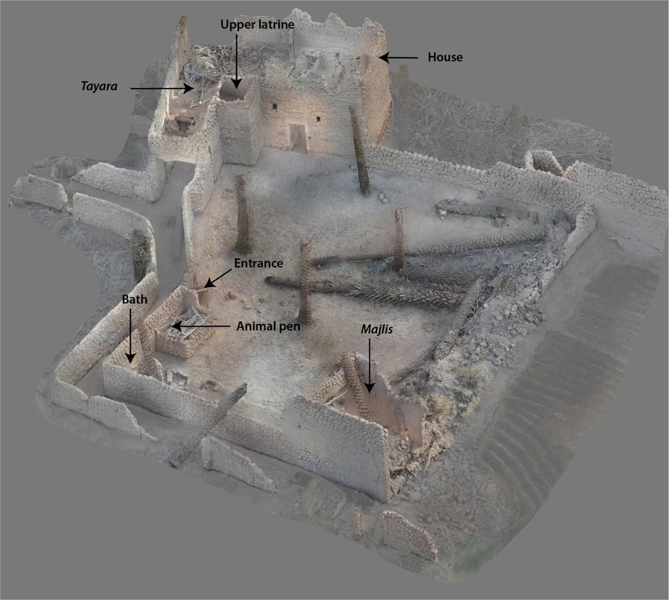
Figure 28. 3D view of an oasis farm, showing the layout of the buildings around the plot. Image ©Archaïos.

Why UCOP matters: Advancing oases studies

The AlUla Cultural Oasis Project demonstrates that al-ʿUlā was not a passive stopover on trade and pilgrimage routes. Rather, it was a complex socio-economic landscape throughout the Islamic and Ottoman periods.

UCOP’s multidisciplinary approach offers a holistic model for studying oases. By placing spatial organization at the core of analysis, the project significantly renews the archaeology of oases and offers a transferable methodological framework for future research on oasis landscapes in arid regions.

The results of the project are currently being published in a scientific monograph that will soon be submitted to a publishing house. This book presents a chronology of the oasis, from the Hegira to the present day. It shows that the oasis underwent constant redevelopment in response to particularly changing trade routes and successive political powers in the Middle East, whose influence was felt in spite of the region’s apparent isolation. The oasis has, thus, remained connected to long-distance trade networks extending as far as East Asia throughout its history (including between the 12th and the 19th century AD, a period that has been very poorly documented until now). Our work also demonstrates the role of the social organization of the population of the al-ʿUlā Oasis—which is divided into two main groups—in the spatial structuring of the palm grove, particularly in terms of the layout of circulation networks and the distribution of dwellings.

The project’s insights into traditional water management and land use also provide valuable lessons for modern sustainability efforts. It highlights the importance of sharing qanat water for the sustainability of the oasis. Conversely, the introduction of new pumping techniques in the mid-20th century (i.e., the diesel-powered pumps which were progressively replaced by drilled wells and electric submersible pumps) marked the transition from community-based and relatively sustainable groundwater management to their “mining exploitation” through individual installations. This has made it possible to significantly expand cultivated areas, but it also caused the rapid lowering of the water table, which led to the complete drying-out and abandonment of qanats in the 1970s-1980s. Our archaeological approach allows us to identify these changes on a fine scale, demonstrating the role of this discipline in understanding contemporary dynamics. By documenting how past communities thrived in arid environments, UCOP thus contributes to contemporary discussions on water conservation, climate adaptation, and heritage preservation. As climate change and water scarcity threaten oases worldwide, UCOP’s work is a reminder of the enduring importance of these landscapes, not just as historical sites, but as models of resilience and adaptation in some of the planet’s harshest environments.

Bibliography

Bouchaud, C., Purdue, L., Deschamps, P., Charbonnier, J., Ducousso, M., Sélosse, M.-A., Boukcim, H., Battesti, V., Gros-Balthazard, M., Forman, S., Dodinet, É., 2023. The Oasis Project: a multidisciplinary study of the AlUla oasis, in: Nehmé, L., AlSuhaibani, A. (Eds.), AlUla, Wonder of Arabia. Skira, Paris, pp. 33–41.

Charbonnier, J., Kanhoush, Y., 2022. AlUla Oasis (UCOP), in: Périssé, I., Alzahrani, A. (Eds.), Le Vingtième Anniversaire de La Coopération Archéologique Franco-Saoudienne. Agence française pour le développement d’AlUla (AFALULA), Paris, pp. 153–161.

Charbonnier, J., Kanhoush, Y., Devaux, E., Gravier, J., Bernollin, V., Hofstetter, T., Giraud, J., 2025. AlUla Old Town and Oasis: Preliminary Results from the Study of the Farms Conducted within the Framework of the AlUla Cultural Oasis Project (Kingdom of Saudi Arabia), in: Rainer, L., Guerrero Baca, L.F., Matero, F.G., Meyer, L. (Eds.), Terra 2022 : Proceedings of the 13th World Congress on Earthen Architectural Heritage : Looking Back, Moving Forward : Advances in Conservation, Santa Fe, New Mexico, USA, June 7-10, 2022. Getty Conservation Institute, Los Angeles, pp. 488–494.

Charbonnier, J., Kanhoush, Y., Gravier, J., Gourret, G., Achouche, I., Bernollin, V., Boudia, S., Bucci, W., Chiti, B., Clauss-Balty, P., Colard, V., Devaux, E., Dupont-Delaleuf, A., Smet, A.D., Furstos, C., Goy, J., Haze, M., Hofstetter, T., Housse, R., Huet, T., Marquaire, C., Pellegrino, M.P., Raad, C., Ricart, J.-D., Rosak, A., Saïd, A.F., Serres, D., Siméon, P., Tourtet, F., Giraud, J., 2022. Mapping an Arabian Oasis: First Results of the UCOP Systematic Survey of al-ʿUlā (AlUla) Valley (2019–2021), in: Foote, R., Guagnin, M., Périssé, I., Karacic, S. (Eds.), Revealing Cultural Landscapes in North-West Arabia, Supplement to Volume 51 of the Proceedings of the Seminar for Arabian Studies. Archaeopress, Oxford, pp. 51–81.

Clauss-Balty, P., Kanhoush, Y., Ben Bader, S., Charbonnier, J., 2023. Preliminary analyses of vernacular earthen architecture in the gardens of al-ʿUlā oasis (Saudi Arabia). Proceedings of the Seminar for Arabian Studies 52, 87–105.

Defauconpret, A., Gravier, J., Charbonnier, J., Gourret, G., Leschallier de Lisle, A., Sepeau, S., Kanhoush, Y., 2024. Geolocation of Old Photographs and Rephotography in the Field: Contribution to a New Understanding of the al-ʿŪla Oasis in the Early 20th Century a.d. Journal of Field Archaeology 49, 653–673. https://doi.org/10.1080/00934690.2024.2391641

Furstos, C., Pellegrino, M.P., Gourret, G., Kanhoush, Y., Charbonnier, J., 2023a. Étude typologique des bracelets en verre découverts dans l’oasis d’Al-Ula (Arabie Saoudite) : de l’époque mamelouke à la fin de l’Empire ottoman. Bulletin de l’Association Française pour l’Archéologie du Verre 2023, 92–98.

Furstos, C., Pellegrino, M.P., Leschallier de Lisle, A., Kanhoush, Y., Charbonnier, J., 2023b. Long-distance trade in al-ʿUlā from the Mamluk period to the twentieth century AD: technological, morphological, and compositional study of glass bangles collected in al-ʿUlā oasis (Hejaz, Saudi Arabia). Proceedings of the Seminar for Arabian Studies 52, 121–137.

Marquaire, C., Charbonnier, J., Gourret, G., Said, A.F., Bernollin, V., Kanhoush, Y., 2022. Study and mapping of wells in the oasis of al-ʿŪla (poster). Proceedings of the Seminar for Arabian Studies 51, 221–229.

Rosak, A., Le Doaré, M., Charbonnier, J., Furstos, C., Pellegrino, M.P., Tourtet, F., Kanhoush, Y., 2025. An Early-Middle Islamic Waterscape in the Hejaz? A Newly Discovered Qanat Network in the Vicinity of Qurḥ (al-Mābiyāt). Open Quaternary 11, 1–22. https://doi.org/10.5334/oq.140

Sepeau, S., Charbonnier, J., Kanhoush, Y., 2024. AlUla: Oasis of Arabia. Éditions Faton, Dijon.

Tourtet, F., Pellegrino, M.P., Furstos, C., Leschallier de Lisle, A., Gourret, G., Haze, M., Ricart, J.-D., Kanhoush, Y., Charbonnier, J., 2024. An archive of 4000 years of human occupation in the al-ʿUlā Valley: a preliminary diachronic study of the pottery record. Proceedings of the Seminar for Arabian Studies 53, 292–315.

Go back to top