Neanderthals and Lions: Early Evidence for Bone Toolmaking from Scladina Cave (Belgium)

Grégory Abrams1,2 & Stéphane Pirson3,4

1 ArcheOs, Research Laboratory for Biological Anthropology, Ghent Archaeological Sciences Centre, Department of Archaeology, Ghent University, Ghent, Belgium

2 Scladina Cave Archaeological Centre, Espace muséal d’Andenne, Andenne, Belgium

3 Direction scientifique et technique, Agence wallonne du Patrimoine, Namur, Belgium

4 Department of Geology (RU Geology) and European Archaeometry Centre (RU Art, Archaeology, Heritage), University of Liège, Liège, Belgium

A unique relationship between Neanderthals and lions

Throughout prehistory, large predators like lions inspired both fear and respect. For Neanderthals, who shared Ice Age landscapes with these formidable carnivores, such animals were not just competitors—they were sometimes resources. At Scladina Cave in Belgium, recent discoveries have revealed a striking example of this relationship: the earliest known evidence of bone tools made from cave lion (Panthera spelaea) remains (Abrams et al., 2025).

This discovery offers new insights into Neanderthal adaptability, craftsmanship, and their nuanced engagement with other large predators.

Scladina Cave and its Middle Pleistocene record

Scladina Cave lies in the Meuse Valley of Belgium, between Andenne and Namur. See Figure 10. Since excavations at the site began in 1978, it has yielded one of Europe’s richest stratigraphic sequences for the Middle and Late Pleistocene—more than 130 stratigraphic layers spanning roughly 400,000 years (Pirson et al., 2014; Vonhof et al., 2024). Among these, Unit 5 preserves evidence of Neanderthal activity dated slightly before 130,000 years ago (the end of the Saalian, MIS 6).

The Neanderthals who occupied the cave at that time left behind a Mousterian stone toolkit and a faunal assemblage dominated by chamois and reindeer (Moncel et al., 1998). They also used animal bones as tools, particularly retouchers—fragments of bone used to sharpen and shape stone flakes (Abrams et al., 2014).

Until recently, all known retouchers from Scladina were made from herbivore or cave bear bones. The identification of several lion bone retouchers, however, adds a new and exceptional dimension to the record.


Figure 10. Location of Scladina Cave in the Meuse Valley, Belgium. The site sits between Andenne and Namur and has yielded a rich stratigraphic sequence related to the Late Middle Pleistocene and the Upper Pleistocene.

Transforming lion bones into tools

Four bone fragments from a single cave lion tibia were identified as having been deliberately modified and used as tools. See Figure 11. The bones show clear impact marks, scores, and embedded stone fragments—typical traces of retouchers used to refine flint edges. Detailed analysis, including proteomics (ZooMS and LC-MS/MS), confirmed the species as Panthera spelaea, the extinct cave lion.

Microscopic examination revealed that the lion tibia had gone through a sequence of transformations. Initially, it seems to have been shaped into an intermediate tool, such as a chisel. After having been broken, the fragments were then used as retouchers. This reuse pattern shows that Neanderthals could repurpose tools for multiple functions—evidence of planning, skill, and resourcefulness.


Figure 11. Bone retouchers made from a cave lion tibia discovered in Scladina Unit 5. Traces of shaping, impact marks, and polish indicate sequential use as multiple tool types. Pictures G. Abrams, Drawing: S. Lambermont.

Why use lion bones?

The choice to use a cave lion’s bone rather than bone from a more common species such as bear or deer raises intriguing questions (Blasco et al., 2010; Russo et al., 2023). Was this simply opportunistic, or did it hold deeper meaning?

At Scladina, Neanderthals often worked with fresh bones, suggesting they had access to the animals shortly after death. The lion bones show no signs of carnivore gnawing or prolonged exposure, hinting that a partial carcass may have been brought into the cave intentionally—perhaps shortly after hunting or scavenging.

Although it is impossible to prove direct hunting, the careful processing and reuse of the lion bones suggest that Neanderthals interacted with one of their main ecological rivals close to its death. Even if purely practical, such actions reflect confidence and technical knowledge in handling dangerous animals and their remains.

A broader perspective on Neanderthal ingenuity

The Scladina discoveries fit within a growing body of evidence showing that Neanderthals made systematic and creative use of bone as a raw material. Across Europe, they shaped bones from a variety of animals—bear, reindeer, horse, even other Neanderthals, and now lion—into tools of standardised sizes and forms. This consistency implies a shared technological understanding rather than ad-hoc improvisation.

The use of carnivore remains is particularly noteworthy. At Scladina, most bone tools came from cave bears, but the presence of lion retouchers shows that Neanderthals were not limited by species. They selected bones based on functional qualities—shape, size, and strength—rather than symbolism.

Still, the fact that these tools came from such a rare and powerful predator cannot help but invite symbolic interpretation. If Neanderthals were indeed aware of the lion’s status in their ecosystem, using its bones may have carried an additional significance.

Interpreting the find

In addition to the tibia used for making retouchers, some other lion remains have been found in Scladina Unit 5. They all belong to one adult individual, mostly limb bones found near the cave entrance. The tibia fragments show multiple phases of use: first as a shaped intermediate tool, later fragmented and reused as retouchers.

This multifunctional transformation—from chisel-like tool to flint retoucher—demonstrates a level of technical reasoning. Combined with the evidence from cave bear remains, it suggests that Scladina’s Neanderthals possessed a well-developed operational sequence for producing, using, and reusing bone tools.

What this means for our understanding of Neanderthals

The Scladina finds highlight Neanderthals’ versatility, planning skills, and deep environmental awareness. They were not passive scavengers but active participants in complex ecosystems, fully capable of repurposing materials—including the bones of formidable predators—for practical ends.

These tools stand as the earliest known example of lion bone toolmaking, pushing back the evidence of such behaviour to the late Middle Pleistocene. More broadly, they remind us that Neanderthal ingenuity extended well beyond stone technologies.

As new analytical methods like ZooMS and LC-MS/MS continue to refine species identification (Bray et al., 2023), we can expect further surprises from sites like Scladina—each one helping us see Neanderthals less as primitive hunters, and more as innovative craftspeople deeply engaged with their world.

Acknowledgements

This research was conducted as part of the Scladina Cave permanent excavation programme managed by the Espace muséal d’Andenne with the support of the Wallonia-Brussels Federation, the City of Andenne, and the Wallonia Heritage Agency.

Bibliography

Abrams, G. et al. (2014). When Neanderthals used cave bear (Ursus spelaeus) remains: Bone retouchers from Unit 5 of Scladina Cave (Belgium). Quaternary International, 326–327, 274–287.

Abrams, G. et al. (2025). Earliest evidence of Neanderthal multifunctional bone tool production from cave lion (Panthera spelaea) remains. Scientific Reports, 15(1), 24010.

Blasco, R. et al. (2010). The hunted hunter: The capture of a lion (Panthera leo fossilis) at Gran Dolina, Atapuerca, Spain. Journal of Archaeological Science, 37, 2051–2060.

Bray, F. et al. (2023). Extinct species identification from late Middle Pleistocene bone fragments by enhanced proteomics. Archaeometry, 65, 196–212.

Moncel, M-H et al. (1998). Halte de chasse au chamois au Paléolithique moyen : la couche 5 de la grotte Scladina (Sclayn, Namur, Belgique). Economie préhistorique : les comportements de subsistance au Paléolithique XVIIIe Rencontres Internationales d'Archéologie et d'Histoire d'Antibes: Editions APDCA, Sophia Antipolis; 1998. p. 291–308.

Pirson, S. et al. (2014). The palaeoenvironmental context and chronostratigraphic framework of the Scladina Cave sequence. In M. Toussaint & D. Bonjean (eds), The Scladina I-4A Juvenile Neandertal (Andenne, Belgium). Palaeoanthropology and Context (pp. 69–92). Liège: ERAUL 134.

Russo, G. et al. (2023). First direct evidence of lion hunting and the early use of a lion pelt by Neanderthals. Scientific Reports, 13, 16405.

Vonhof, H. et al. (2024). Improving the age constraints on the archeological record in Scladina Cave (Belgium): new speleothem U–Th ages. Climate of the Past, 20(12), 2741–2758.

Go back to top 

Ancient cities in the rainforest

Stéphen Rostain1 & Antoine Dorison2

1 French National Center for Scientific Research (CNRS), ‘Archaeology of Americas’ laboratory, France

2 Newcastle University, Newcastle-upon-Tyne, UK

What is a city? To a Western mindset, the term immediately evokes the idea of a group of buildings, often arranged along streets and, in older examples, usually surrounded by defensive walls or moats. However, the concept has widened considerably, and archaeology has played its part in this development. As a result, we now recognize multiple expressions of cities around the world, especially in the Northern Hemisphere. Although recognition of this diversity is now quite well-accepted, it took several more decades for scholars to incorporate into the concept of city examples that differed from an often glorified classical model, such as Angkor Wat in Cambodia, the Mayan centers of the Yucatan Peninsula, and the cities of ancient Peru. Even then, these are often referred to as ‘pre-urban’, implying evolution and, thus, an unfinished development process. By such criteria, only a few prestigious tropical forest societies are thereby placed on the so-called path of progress. The situation intimates that the construction of sustainable cities by indigenous peoples in the Amazon would be relocated to the realm of fiction, rather than history! And yet...
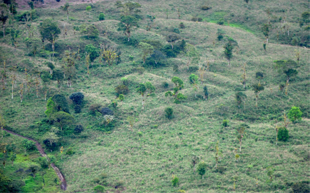

Figure 12. Artificial mounds in the Upano Valley, Ecuadorian Amazonia. Photo by S. Rostain.

In 2024, Science published the discovery of original urban manifestations in the upper Ecuadorian Amazon (Rostain et al. 2024). Although the existence of artificial earth mounds in the Upano Valley associated with dug paths had been known for some time (Porras 1987; Rostain 1999) (Figure 12), no one suspected the considerable extent and number of these developments. The exceptional importance of this garden urbanism was revealed by the interpretation of LiDAR images covering 600 km² along the raised terraces which thrust up from the valley floor (the Upano River is deeply dug in between cliffs that measure over 100m; Rostain et al. 2024). This discovery led to a profound reconsideration of what was previously known about the ancient indigenous cultures of this part of the Amazon.
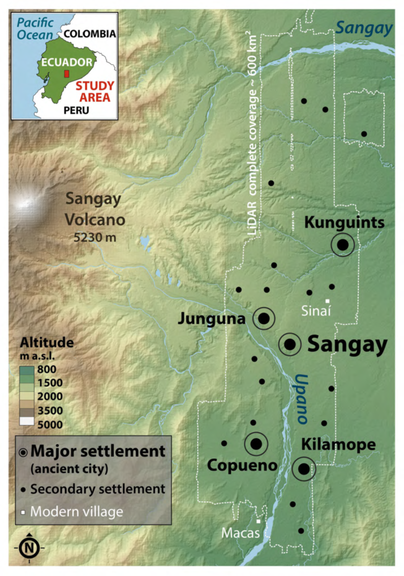

Figure 13. Archaeological map of the Upano Valley and extension of the Lidar survey covering. Map by A. Dorison and S. Rostain.

A gradual discovery

Unlike some archaeological projects where field investigations only developed following discoveries revealed by LiDAR, research in the Upano went the other way round. See Figure 13. It all began in the late 1970s when Father Juan Botasso, stationed in the colonial town of Macas in the same valley, was visiting his indigenous parishioners when he noticed several rectangular mounds of earth that appeared to be man-made (Saulieu et al. 2020). Later, he welcomed his colleague Pedro Porras from Quito, and took him to visit these unusual mounds. Porras then returned to Quito to announce that he had just discovered a new archaeological site, which he named Sangay, after the volcano overlooking the valley. Although Porras had little experience in excavation, he organized a dig and a mapping survey with his university students at the site. These revealed a 100-ha wide settlement with over 170 earthen platforms organized in small groups of four to six, all connected by dug footpaths, leaving little doubt as to the urban nature of the establishment. See Figure 14. However, when Porras published the first monograph, he interpreted the site as primarily—if not exclusively—ceremonial (Porras 1987).
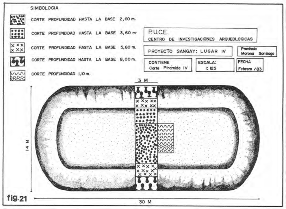

Figure 14. Main excavation made by Pedro Porras in the Sangay site (after Porras 1987).

A professional archaeological project was launched in 1996 by Stéphen Rostain, initiating a seven-year-long Franco-Ecuadorian collaboration to conduct research in the Upano Valley. See Figure 15. Excavations and surveys were carried out with international specialists from various disciplines (botanists, soil scientists, geologists, volcanologists, etc.). Several new sites were discovered. See Figure 16. Beside test-pits and given the size of the sites and the artificial mounds (often over 20 m long), Rostain and his team undertook the very first large-scale excavations in open areas in the Ecuadorian Amazon. See Figure 17. Following preliminary stratigraphic test-pits, two groups of mounds were excavated manually at two different sites to uncover each layer of occupation over a large area. See Figure 18. Well-preserved domestic floors were discovered at the top of the mounds. The methods used for their construction were also revealed, which also shed light on the chronology of the valley’s occupation (Rostain 2006, 2023). The Kilamope and Upano archaeological cultures were, thus, identified. See Figures 19-20. The groups belonging to the Kilamope Culture (the older of the two) seem to have begun building earthen mounds around 1000 BC. However, it was likely the Upano groups—contemporaries or successors of the former—who were responsible for the intense modification of the valley’s landscape from 400-100 BC to 400-600 AD. After a long hiatus, some mounds were re-occupied by groups from the so-called Huapula Culture between 800 and 1200 AD (Rostain 1999, 2023). See Figure 21.
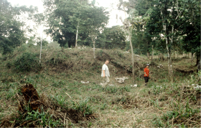

Figure 15. Artificial earth platforms found during the 1996 surveys. Photo by S. Rostain.
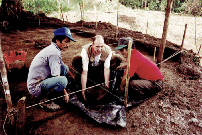

Figure 16. Extraction of a Huapula Culture jar from the upper occupation floor of a platform at the Sangay site. The first author is in the center. Photo by S. Rostain.
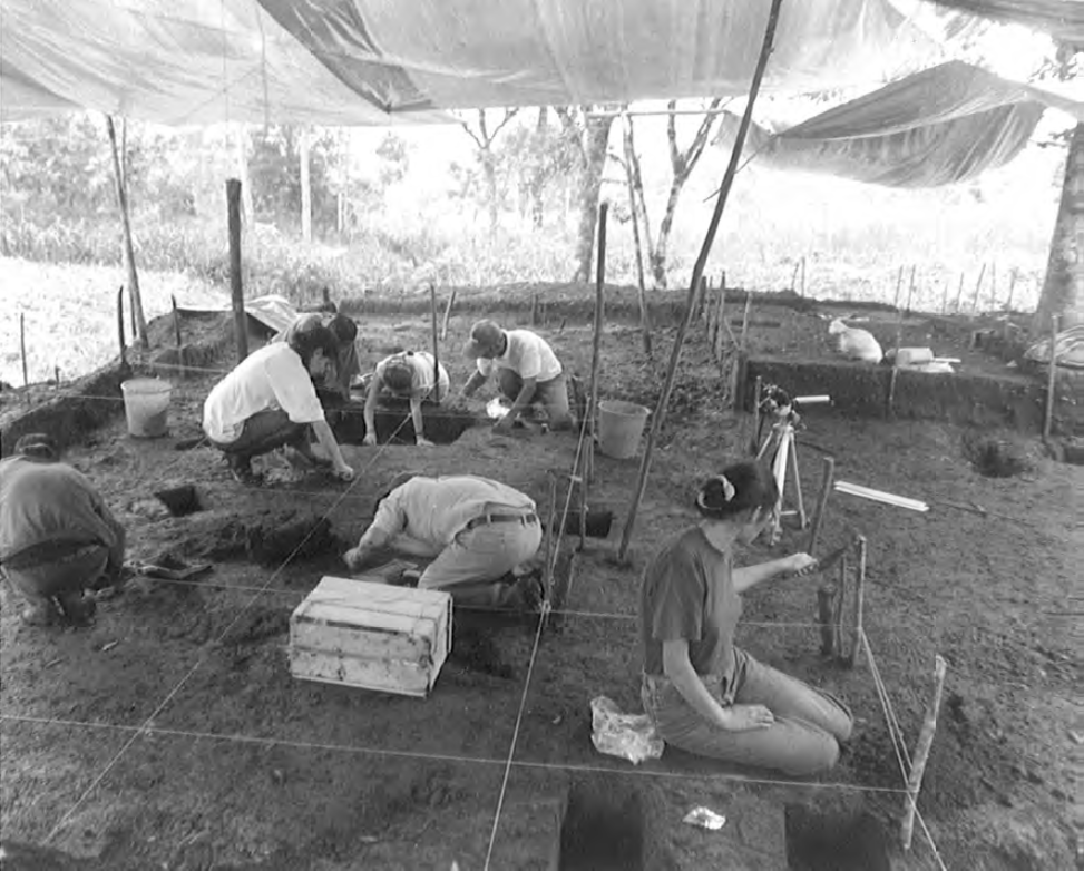

Figure 17. Large-scale excavation at the top of a residential platform, Sangay site. Photo by S. Rostain.
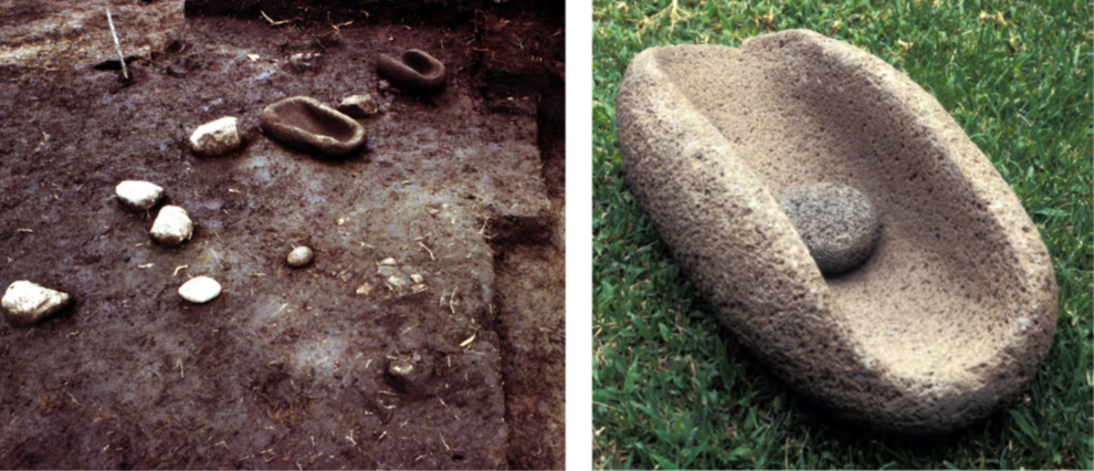

Figure 18. Kitchen floor at the top of a residential platform of the Huapula Culture in the Sangay site. At right, the millstone and its grinder seen in the background of photo at left. Photos by S. Rostain.
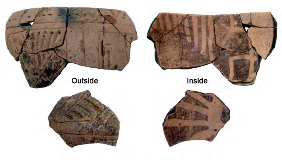

Figure 19. Typical pottery bowl with corded print outside and negative painting inside of the Kilamope Culture. Photo by S. Rostain.
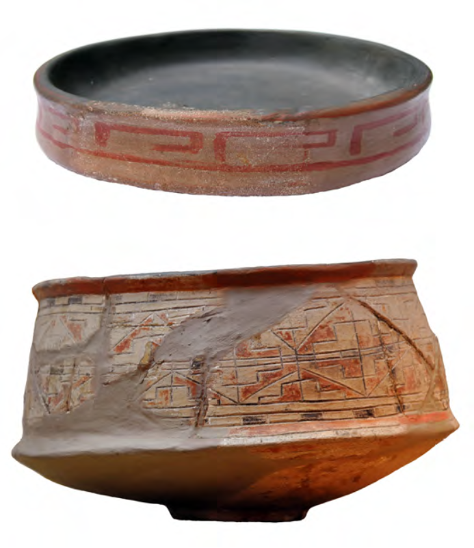

Figure 20. Typical red-banded and incised pottery recipients of the Upano Culture. Photo by S. Rostain.
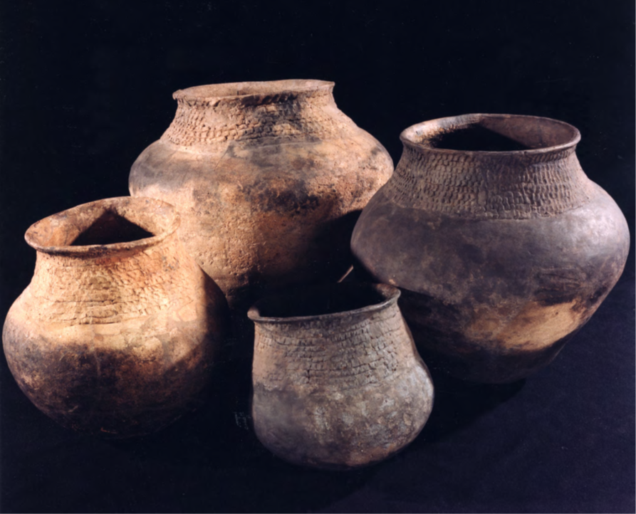

Figure 21. Large jars for the cassava beer of the Huapula Culture. Photo by R. Jones and S. Rostain.
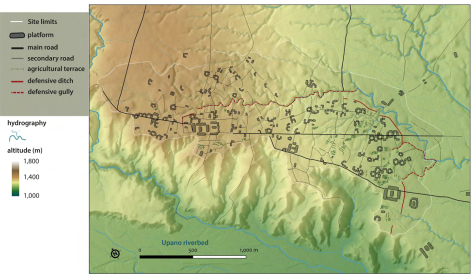

Figure 22. Map of the Sangay site. Map by A. Dorison.

The regional survey revealed the existence of other mound clusters on the high terraces bordering both sides of the Upano River, although none equaled the size of Sangay. See Figure 22. These ancient societies, therefore, occupied a territory larger than this single settlement. However, we had no idea at the time that we had only just scratched the surface of the true extent of this mound building phenomenon.

The sites seen from the sky

Excavations by Rostain’s team in the Upano Valley ended in 2003. No major excavations were carried out thereafter, as national Ecuadorian archaeology tended to focus on the coastal and Andean regions, which were considered more prestigious by the public. However, the Upano Valley was not forgotten and, twelve years later, advances in remote sensing technology provided a more complete picture of its ancient occupation. In 2015, the Ecuadorian Institute of Cultural Heritage (INPC) commissioned a LiDAR survey covering a 600-km² area ranging from the Upano Valley to the headwaters of the Pastaza River (Technoproject 2015). This technology, now well known to archaeologists, provides a very accurate model of the terrain under the vegetation cover, revealing a landscape that cannot be observed directly either on the ground or from the air. Although an article summarizing the data and interpretations of the technical report was published locally (Sánchez-Polo and Álvarez Litben 2023), with no associated fieldwork and little exposure within the archaeological community, let alone internationally. In 2021, the INPC independently entrusted Rostain’s team with the raw LiDAR data0F in order to start a new analysis from scratch. Thanks to the collaboration of the second author of the present paper, the results of this work were published two years later and revealed to the world (Rostain et al. 2024).
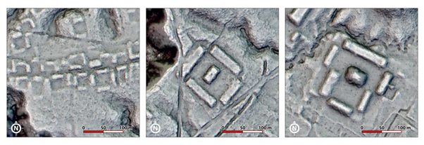

Figure 23. Domestic (left) and civic (right) platforms. Image by A. Dorison and S. Rostain.

Where previously, only a few artificial mounds and dug paths could be seen, a myriad of anthropogenic features appeared on the digital image. The first things that can be detected in the field or on LiDAR images are the artificial earth mounds. Remote sensing has made it possible to count more than 6,700 of them! Most of these are rectangular platforms ranging from 10 to 140 meters in length, 3 to 20 meters in width, and 2 to 8 meters in height (Rostain 2012a, b). Their layout follows a standardized pattern, consisting of a square plaza or patio surrounded by peripheral mounds, with a central platform in some cases. See Figure 23. The most common of these so-called complexes measure 40 meters on each side and are interpreted as residences based on excavations (Rostain 1999). See Figure 24. However, there are also much larger complexes—both in terms of surface area and platforms—which probably bear a civic and ceremonial function. The largest complex (at Kilamope) covers ten hectares and includes a platform measuring 140 by 40 meters. See Figure 25. The average density is 16.6 platforms/km², but some areas have densities exceeding 100 elements/km² (Rostain et al. 2024).
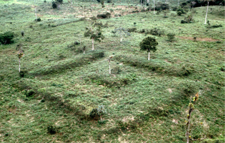

Figure 24. Complex of residential platform in the Kilamope site. Photo by S. Rostain.
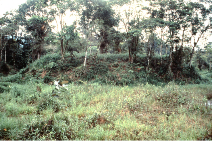

Figure 25. Large civic mound in the Domono site. Photo by S. Rostain.

Not only was the site of Sangay much more impressive than previously imagined, but there were also several other similar cities in the surrounding area where only a handful of isolated complexes had been detected hitherto.

Amazonian urbanism

The sites in the valley turned out to be much more than just clusters of mounds, but some are actual urban centers (Rostain et al. 2024). In fact, almost all of the settlements were organized along one or two perfectly straight streets—or avenues—that materialized along an axis which crossed the site from one end to the other. See Figure 26. Stretching over a kilometer in length, these avenues were dug up to 5 meters deep and up to 15 meters wide. Side streets branching off from the central avenue (which were dug less deeply and which connected numerous domestic complexes) formed a network that organized the entire settlement into a more or less regular grid pattern. See Figure 27. The larger complexes (the ones believed to have had a civic or ritual function) were located at one or both ends of the avenues.
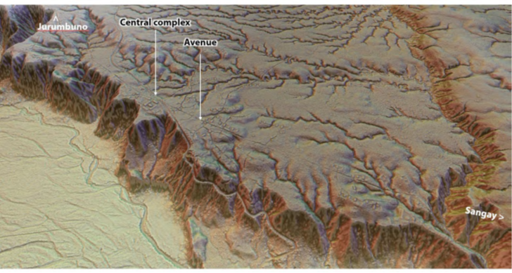

Figure 26. Central avenue of the Junguna site. Image by A. Dorison and S. Rostain.
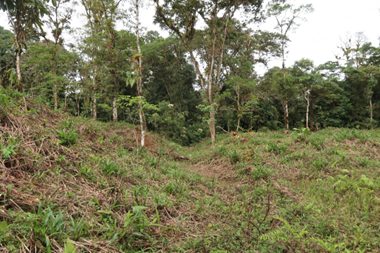

Figure 27. One dug street in the Sangay site. Photo by S. Rostain.
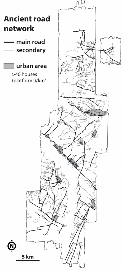

Figure 28. Archaeological road network in the Upano Valley. Map by A. Dorison.

What is even more striking is that this modification and organization of the landscape as defined by a need for axiality and orthogonality continues outside the clustered areas through a dense road network on the regional scale. Though less dense, numerous other sites consisting of residential and civil buildings and even isolated platform complexes form nodes in the gridded pattern thereby created. Avenues extend beyond the agglomerated cities limits toward other settlements. They thus turn into roads, dug to varying depths cross the region, extending over 10, 15, and even more than 25 kilometers. These are characterized by running in a straight line, without deviation in spite of natural irregularities in the terrain. These roads cut through the slightest elevation, cross valleys, and climb hills. This type of dispersed settlement pattern is reminiscent of other American examples of “low-density urbanism” (Isendahl and Smith 2013), but the almost obsessive orthogonality of the Upano case is unprecedented. See Figure 28.

Indeed, such straight roads are completely unnecessary in a forest environment. The inhabitants of the region could have travelled perfectly well without such labor-intensive infrastructures. It is therefore reasonable to assume that these roads were not simply economical features. Based on the way current indigenous groups create footpaths in other parts of Amazonia (e.g. Heckenberger 2020), we argue that the Upano roads can be interpreted as physical imprints of social connections between settlements on the landscape. It is plausible that the inhabitants had thereby designed an anthropized landscape with high social and symbolic value in order to facilitate interactions between the various communities in place.
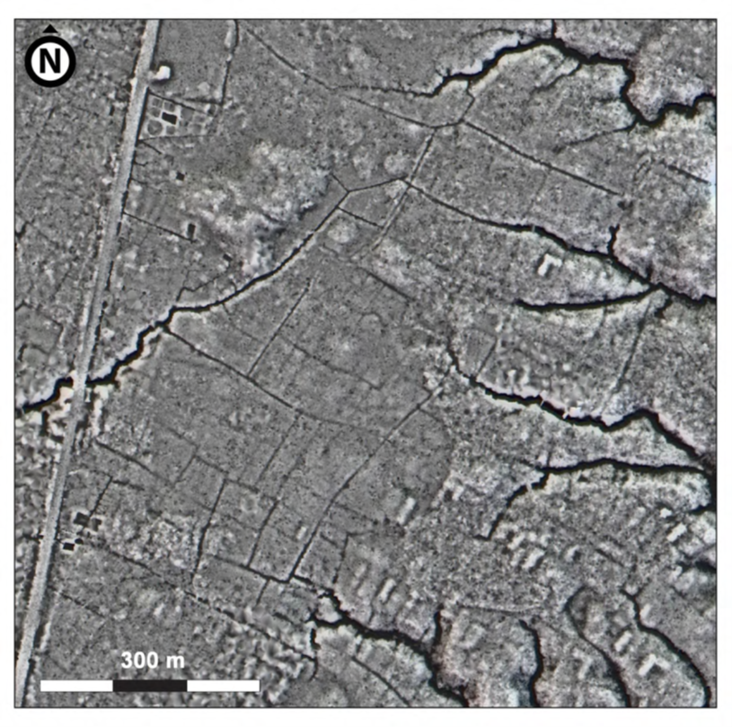

Figure 29. Drained fields in the Yukipa site. Image by A. Dorison and S. Rostain.

Furthermore, beside the roads and the residential and civic features, numerous agricultural remains were also detected. Thus, the seemingly empty spaces between the platforms or roads were often dedicated to fields. On the flat, up-lifted terraces bordering the Upano River, most of these plots are drained fields laid out in vast grids connected with the road network, which allowed excess water to be drained away into the numerous ravines of the agricultural hydrographic system. See Figure 29. The ancient inhabitants also took advantage of the concave slopes—especially at the head of ravines—by building cross-channel terraces. On gently sloping terrains, they raised long ridges. All of this demonstrates a keen understanding of the local geomorphology which prioritized making the most of available space and suggests that the roads also had a role to play in a regional-scale water management program. See Figure 30.
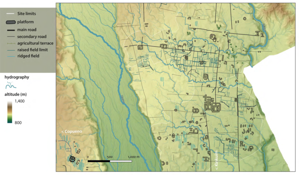

Figure 30. Map of the Kilamope site with the detail of the drained fields between the platforms and along the dug streets. Map by A. Dorison

A domesticated landscape

Archaeological excavations and remote sensing attest to the intimate interaction of indigenous peoples with their environment and with their distant neighbors. The Upano peoples invested intensely in their environment by creating what we like to call ‘green urbanism’, in reference to urban theories from the last century (Howard 2007). The integration of buildings into the landscape made them almost imperceptible, even though they have remained standing for three millennia. See Figure 31.

With its preference for a grid plan and an orthogonal road system, the Upano Valley stands out clearly from other settlement planning choices in the Amazon. In the south and southwest of the region, ancient peoples preferred to organize their settlements in a star pattern with radiating roads. These could take the shape of a huge central mound surrounded by earthen structures and raised roads, as was the case in the Llanos de Mojos in Bolivia (Prümers et al. 2022), or of large houses forming a ring around a huge plaza from which slightly sunken roads radiate, as in the state of Mato Grosso in Brazil (Heckenberger et al. 2008; Heckenberger 2020).
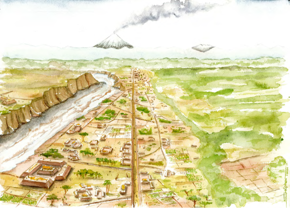

Figure 31. Artistic view of the Sangay site ca. 2000 years ago. Watercolour by S. Rostain.

In any case, it is very likely that, given the amount of labor invested, the Upano Valley was densely populated during the first to centuries AD. The road connections between the c. 20 clustered settlements identified suggest that at least a part of these anthropogenized landscape was contemporary. The occasional presence of earthen fortifications nevertheless indicate that their history is far from linear, with probable periods of increased exchanges and others of tension. A prominent feature of this urban planning is the intertwining of distinct functions (civic-ceremonial and residential at the very least), not only within the cities but also dispersed across the landscape.

Implementing such large-scale projects with sophisticated engineering across an entire valley is difficult to imagine for leaderless societies, as we know them today in the Amazon. It must be acknowledged that some ancient peoples may have been less egalitarian, with a hierarchical system. This monumental public work must have been organized by elites and supervised by specialists, particularly in land surveying. The very existence of this large-scale agrarian urbanism, bringing together housing, ceremonies, ritualized movement, trade, and agriculture in the same space, encourages us to rethink the socio-political and economic organization of the first inhabitants of the Amazon.

Thus, this discovery tell us, once more and contrary to a common misconceptions, that the world’s largest tropical rainforest is far from pristine, but the result of human modifications which took place over thousands of years. Furthermore, the urban system thereby revealed—which probably extended beyond the 600 km² studied—was on a scale which has never before been documented in the South American lowlands. This last forces us to fundamentally reconsider the human past of the upper Amazon.

Bibliography

Heckenberger, Michael J. 2020. ‘Xingu Garden Cities. Amazonian Urban Landscapes, or What?’ Landscapes of Preindustrial Urbanism, edited by G. Farhat, Dumbarton Oaks Research Library and Collection, Washington, DC: 225-262.

Heckenberger, Michael J., Christian Russell, Carlos Fausto, Joshua R. Toney, Morgan J. Schmidt, Edithe Pereira, Bruno Franchetto, and Afoba Kuikuro 2008. ‘Pre-Columbian urbanism, anthropogenic landscapes, and the future of the Amazon’ Science, 321: 1214-1217.

Howard, Ebenezer 2007 [1902]. Garden Cities of Tomorrow, Routledge, London.

Isendahl, Christian, and Michael E. Smith 2013. ‘Sustainable agrarian urbanism: the low-density cities of the Mayas and Aztecs’ Cities, 31: 132-143.

Porras, Pedro 1987. Investigaciones arqueológicas a las faldas del Sangay: Tradición Upano, Centro de Investigaciones Arqueólogicas, PUCE, Quito, Ecuador.

Prümers, Heiko, Carla Jaimes Betancourt, José Iriarte, Mark Robinson, and Martin Schaich 2022. ‘Lidar Reveals Pre-Hispanic Low-Density Urbanism in the Bolivian Amazon’ Nature, 606 (7913): 325-328.

Rostain, Stéphen 1999. ‘Secuencia arqueológica en montículos del valle del Upano en la Amazonia ecuatoriana’. Bulletin de l’Institut français d’études andines, 28 (1), Lima: 53-89.

Rostain, Stéphen 2006. ‘Etnoarqueología de la casa Huapula y Jívaro’ Bulletin de l’Institut Français d’Études Andines, 35(3), Lima: 337-346.

Rostain, Stéphen 2012a. ‘Between Sierra and Selva: pre-Columbian landscapes in the upper Ecuadorian Amazonia’ Quaternary International, 249, Elsevier: 31-42.

Rostain, Stéphen 2012b. Islands in the rainforest. Landscape management in pre-Columbian Amazonia, Left Coast Press, Walnut Creek.

Rostain, Stéphen 2023. ‘Tolas, terrazas y casas: arqueología del valle del Upano’ Strata, 1(1), Quito.

Rostain Stéphen, Antoine Dorison, Geoffroy de Saulieu, Heiko Prümers, Jean-Luc Le Pennec, Francisco Mejía Mejía, Anna M. Freire, Jaime R. Pagán-Jiménez, and Philippe Descola 2024. ‘Two Thousand Years of Garden Urbanism in the Upper Amazon’ Science, 383(6679): 183-189.

Sánchez-Polo, Alejandra, and Rita Álvarez Litben 2023. ‘Un paisaje monumental prehispánico en la Alta Amazonía ecuatoriana: primeros resultados de la aplicación de Lidar en el valle del Upano’ Strata, 1(3), Quito.

Saulieu, Geoffroy de, Stéphen Rostain, Anne-Christine Taylor, and Philippe Descola 2020. ‘Entre châtaigner et palmier chonta. Hommage à Juan Bottasso (1936-2019)’ Journal de la Société des Américanistes, 106(1), Paris: 175-180.

Technoproject 2015. ‘Informe del levantamiento aéreo y del análisis preliminar e identificación de las anomalías del relieve relacionadas con las estructuras arqueológicas. Superficie Upano-Mera’ Ms. Unpublished field report, INPC, Quito.

Go back to top 

The Roman Period Mass Grave from Wien-Simmering

Michaela Binder1, Kristina Adler-Wölfl2, Michaela Kronberger3, Martin Mosser2, Christoph Öllerer2, Sheridan Strang1 & Anette Slonek1

1 Novetus GmbH, Vienna, Austria

2 Stadtarchäologie Wien, Vienna, Austria

3 WienMuseum, Vienna, Austria

During October 2024 construction works for a new football stadium in the Viennese district of Simmering, a unique archaeological site was accidentally discovered. Over the course of six weeks of excavation, the human skeletal remains of 129 individuals buried together in an oval shaped pit were uncovered under the guidance of the Stadtarchäologie Wien. See Figure 32. Laid down in an irregular manner, intertwined and up to five bodies deep, the mass grave gives an impression of an unceremonious disposal of corpses rather than an actual burial site. Research into the identity of the individuals and the background of their death has only just started; this contribution summarizes the results of what we know so far.


Figure 32. The Simmering mass grave. Photo by A. Slonek/ Novetus GmbH, with permission.

The burial site

The mass grave is located on the eastern site of Vienna 3 km to the south of the Danube River which marked the border between the Roman empire and the territories of the Germanic tribes to the north. See Figure 32. While today this is a densely settled urban area, in the Roman period, this would have likely been uninhabited no-mans-land between the military camps of Vienna/ Vindobona 5 km to the northwest and Schwechat/Ala Nova 4 km to the southeast. See Figure 33. Even though one third of the feature was largely destroyed during construction works, it can be reconstructed to comprise a simple shallow oval-to-rectangular pit (4.49m (NW-SO) by 5.09m (SW-NO) with a depth of 0.55m). 129 individuals were recovered intact or partially intact, but a large amount of disarticulated remains were recovered from the spoil heap, indicating that perhaps as many as 150 individuals were buried in the mass grave. The close packing and intertwining of individuals leaves no doubt that burial was carried out in a single event. Absence of evidence for scavenging suggests that the pit was backfilled shortly after burial. Additionally, the full preservation of all joint articulations identifies the site as their primary place of burial.


Figure 33. Map of the Roman province of Pannonia during the 1st century AD. Map by M. Mosser/Stadtarchäologie Wien, with permission.

Only a very small number of objects was recovered in association with the bodies, these are all the more significant what regards both dating and entangling the background of the mass grave. Found alongside one of the deceased’s femurs was a heavily corroded iron dagger with sheathing. Upon x-raying the finds, a décor made from silver inlay was revealed, allowing for a dating to the late 1st century AD and an attribution the Roman army (Weller et al., 2020). See Figure 34. This is consistent with several dislocated fragments of scale armour made from copper alloy and found scattered between the bodies, the cheek flap of a helmet (Figure 35), two lance heads and a number of iron shoe nails which are also typical constituents of Roman period armour.


Figure 34. Dagger recovered from the mass grave (left) and a radiographic image of the sheath. Photo by L. Hilzensauer/ Wien Museum; TimTom Wien, with permission.


Figure 35. Cheek flap of a Weisenau type helmet. Photo by L. Hilzensauer/ Wien Museum, with permission.

The human remains

Following recovery, the human skeletal remains were carefully washed, dried and subjected to a bioarchaeological analysis within the framework of the documentation required by the Austrian Federal Monuments Office (Bundesdenkmalamt, 2024). The choice of methods followed international standards in bioarchaeology (summerized in Buikstra and Ubelaker, 1994, Mitchell and Brickley, 2017). Bone preservation was variable with a moderate degree of fragmentation and 25-75% of cortical surfaces being intact. Of the 129 individuals recovered, 92 (71%) were complete enough preserved to assess biological sex and age-at-death. All of the individuals were estimated to be male or probable male. 65.4% were less than 35 years old at death, the youngest three had only reached an age of 15-18 years. Old adults were absent from the group. Calculation of stature was possible in 75 (58%) of the men from the Simmering mass grave with an average stature of 174.1cm. This is significantly higher than in any of the contemporary groups (Giannecchini and Moggi-Cecchi, 2008) which may be attributed to the selection of specific individuals for the requirements set by military standards (Gowland and Walther, 2018).

The most indicative feature of the human skeletal remains from the Simmering mass grave is the high amount of perimortem trauma which affected 40 of the 129 individuals (30%). This value however is likely biased by the incomplete preservation and the fact that not every injury would have affected the skeleton; thus the true frequency would have likely been even higher. The spectrum of injuries sustained by the men was highly variable and included sharp and blunt force as well as projectile trauma. See Figure 36. With regard to body region affected, there was a notable focus on the skull (29% of all injuries) and pelvic region (40% of all injuries). While in the skulls, mainly sharp force trauma was observed (Figure 37), the pelvic region was most commonly affected by projectile injuries. See Figure 38. This may be attributable to specific combat strategies, but is still awaiting more detailed research within the context of Roman military history. Of further note is the shear force with which some of the injuries were inflicted. For example, in several cases cut marks where not only observed in the bones of the skull but also cut through teeth. The types of weapons used in the armed conflict still need to be determined through a more in-depth study of the injuries set against historic information. Most importantly though, the diversity of injuries argues against an execution site such as the mass grave at Skopje/Scupi (Paleopatologia, 2018). Based on the bioarchaeological results in combination with the small finds, it is reasonable to assume that this mass grave was the result of a military conflict.


Figure 36. Examples of projectile injuries arising from pilum (left and right) as well as lance heads (middle). Pictures by S. Strang/ Novetus GmbH, with permission.


Figure 37. Several cut marks in the skull. Photo by S. Strang/ Novetus GmbH, with permission.


Figure 38. Lance head embedded within the pelvis of individual 115. Photo by A. Oecsi/Novetus GmbH, with permission.

Little information has yet been obtained on the state of health of the men due to the fact that a full-scale bioarchaeological analysis in order to establish more complete osteobiographies has not yet been carried out. A preliminary survey as part of the requirements for the reporting to the Federal Monuments Office has nevertheless already brought about several insights. When compared to Roman period attritional cemeteries, dental health was good even though this may be somewhat biased by the young age-at-death. Evidence of severe infectious disease or malnutrition was absent which stands in sharp contrast to later groups of soldiers killed in battle (Quade and Binder, 2018). There were also only a very small number of healed injuries, but these were only minor and would not have affected individuals’ mobility or ability to fight.

Contextualising the event

Based on the small finds as well as several C14-dates carried out on bones from the mass grave, the events leading to brutal killing of up to 150 men can be dated to the late 1st/early 2nd century AD. During this time period, the Danube limes demarcating the border between the Roman provinces in the south and the Germanic territories to the north was only in its early stages of fortification. Vienna/ Vindobona which would grow to host up to 6,000 soldiers and a civil population of up to 30,000 in the 3rd century was yet but a small military camp. Historic sources documenting any military activity in the region during the late 1st/early 2nd century AD to which the Simmering site could securely be attributed have not yet been identified. Only for the year 92 AD, during the reign of Emperor Domitian (81-96 AD), numerous attacks on Roman territory carried out by Sarmatians in the lower and middle Danube regions followed by the Germanic Markomanni and Quadi near Carnuntum were recorded (Strobel, 1989). Whether the Simmering mass grave can be linked to this episode of warfare or another as-yet-unidentified historical event remains the subject of future research. In not cremating the bodies as was customary in the Roman provinces during the 1st and 2nd century AD, the treatment of the dead represents a stark deviation from contemporary, strongly canonical Roman funerary practices (Graen, 2011). This form of punishment beyond death may provide an indication of the relationship between those burying the bodies and the dead themselves.

Significance and outlook

While Roman warfare is well evidenced through historic sources as well as battlefield artefacts such as weaponry and equipment, the Simmering mass grave represents the first example of physical evidence of fallen combatants buried in the aftermath of a military conflict for this place and time. As such, it will offer unparalleled insights into a wide range of aspects into Roman (military) history. In being unburnt, contrary to all other contemporary burial sites, the bodies represent a unique “bio-archive” that for the first time allows for an in-depth study of Roman period soldiers, their origins, relationships, nutrition, health and living conditions through bioarchaeological and biomolecular analyses, including ancient DNA and stable isotopes studies. Ultimately, a dignified resting place will be established, ensuring ethical curation and accessibility for future generations of researchers.

Acknowledgements

The archaeological work was funded by MA 51 – Sport Wien, Wien Museum and the Federal Monuments Office BDA.

Bibliography

Buikstra, J. E. & Ubelaker, D. H. 1994. Standards for Data Collection from Human Remains, Lafayetteville, Arkansas, Arkansas Archaeological Survey.

Bundesdenkmalamt 2024. Richtlinien für archäologische Maßnahmen, Wien.

Giannecchini, M. & Moggi-Cecchi, J. 2008. Stature in archaeological samples from central Italy: Methodological issues and diachronic changes. American Journal of Physical Anthropology, 135, 284-292.

Gowland, R. & Walther, L. 2018. Human growth and stature. In: Scheidel, W. (ed.) The Science of Roman History: Biology, Climate and the Future of the Past. Princeton University Press.

Graen, D. 2011. Tod und Sterben in der Antike: Grab und Bestattung bei Ägyptern, Griechen, Etruskern und Römern, Stuttgart, Theiss.

Mitchell, P. D. & Brickley, M. 2017. Updated Guidelines to the Standards for Recording Human Remains, Reading, Chartered Institute for Archaeologists/British Association for Biological Anthropology and Osteoarchaeology.

Paleopathologia. 2018. Scupi, colonia flavia scupinorum. [Online]. Available: https://www.paleopatologia.it/scupi-colonia-flavia-scupinorum/. [Accessed June 3, 2025].

Quade, L. & Binder, M. 2018. Life on a Napoleonic battlefield: A bioarchaeological analysis of soldiers from the Battle of Aspern, Austria. Int J Paleopathol, 22, 23-38.

Strobel, K. 1989. Die Donaukriege Domitians. Antiquitas, I, 99-104.

Weller, U., Bloier, M. & Flügel, C. 2020. Dolche und Schwerter, Bestimmungsbuch Archäologie 6, München.

Go back to top 

Shaping the Unusual: Earliest Ivory Working at a Lower Palaeolithic Site in Ukraine

Vadim Stepanchuk1,2 & Oleksandr Naumenko3,4

1 Institute of Archaeology, National Academy of Sciences of Ukraine

2 I. Krypiakevych Institute of Ukrainian Studies, National Academy of Sciences, Ukraine

3 National Museum of the History of Ukraine

4 Taras Shevchenko National University of Kyiv

In the landscape of early human history, discoveries that challenge our understanding of prehistoric behaviour are both rare and invaluable. In 2011, an unexpected find emerged in the valley of the Southern Bug River in western Ukraine. Archaeologists identified several open-air sites near the town of Medzhybizh, revealing cultural horizons embedded within a 30-metre-high riverbank. One of these, Medzhibozh A, soon attracted particular attention for a peculiar set of finds: small, knapped fragments of mammoth ivory. What made these fragments exceptional was not only their material, but their age—some dating 400,000 years old.

This discovery invites us to reconsider what we know about early hominin behaviour in Eastern Europe. While shaped bone tools are occasionally found in Middle and Upper Palaeolithic contexts, and ivory becomes a more common medium in the Upper Palaeolithic, evidence of ivory processing in the Lower Palaeolithic has been virtually absent…until now!

A riverbank of stories

The Southern Bug River Valley has long attracted archaeologists for its rich stratigraphy and abundance of prehistoric sites. As mentioned above, near the town of Medzhybizh, excavations have revealed multiple open-air localities embedded within the 30-metre-high Southern Bug River riverbank. See Figure 39.

The site of Medzhibozh A, located within this riverbank sequence, revealed six layers rich in artefacts and faunal remains, interspersed with sterile sands and gleys. The youngest layers (I–II) date to the Holsteinian interglacial (Marine Isotope Stage 11), while the oldest reach back into MIS 35–21. Despite the poor preservation of organic materials, the site yielded a small yet intriguing faunal collection: deer, rhinoceros, horse, and notably, proboscideans—though no complete elephant bones were found.

What did emerge, however, were fragments of ivory. So far, twenty-four pieces have been documented, including twenty-one from the MIS 11 Medzhibozh A assemblage. Most are under on their longest edge and weigh only a few grams. They are weathered, rounded, or discoloured—typical signs of long-term burial and exposure to fluctuating groundwater. Yet several showed something more: evidence of deliberate shaping.


Figure 39. Southern Bug River Valley with the Medzhibozh 1 and Medzhibozh A sites (excavation pit on the right); at Medzhibozh A, culture horizons lie beneath c. 30 m of sediment. Photo by V.Stepanchuk.


Figure 40. Sample ivory fragment from Medzhibozh A showing convergent flaking typical of bipolar-on-anvil technique. Photo by O. Naumenko.

Chipping ivory like stone

Among the twenty-one ivory finds from the Holsteinian levels, eleven showed signs of human modification. Using the same methods applied to flint and quartz pebbles at the site (most notably the bipolar-on-anvil technique), Palaeolithic knappers had also struck, trimmed, and reshaped these tusk fragments.

Two items stand out. One, a small trapezoidal piece with convergent edges, appears to have been shaped into a pointed form. Another bears multiple flake scars and impact marks, suggesting use as a core from which smaller flakes were detached. These are not chance fragments or gnawed refuse; their morphology and flake patterns indicate purposeful shaping by human hands. See Figure 40.

Experiments with well-preserved Pleistocene mammoth ivory from zones of permafrost confirmed that the patterns observed on the archaeological specimens align with intentional percussion knapping. The ivory responds to bipolar percussion with similar fracture mechanics as flint or quartz, though it requires delicate handling due to its specific structure, toughness and tendency to splinter. Lower Palaeolithic knappers likely processed fragments both horizontally and vertically, adjusting each piece to keep control of the difficult material.

Why ivory? Why then?

Ivory is not an easy material to work with. It is softer than stone. It is less predictable than bone. It is susceptible to rapid decay when moisture and temperature vary. Its use as a medium for artefacts in the Palaeolithic typically emerges much later, in the Upper Palaeolithic, when new methods like carving, drilling, and polishing became widespread. At Medzhibozh A, however, ivory seems to have been processed in the same way as stone. See Figure 41.


Figure 41. Experimental knapping of a Pleistocene mammoth tusk fragment using the bipolar-on-anvil technique. Photo by O. Naumenko.

The use of bipolar percussion—placing a piece on an anvil and striking it with a hammerstone—suggests the knappers treated the ivory not as something special, but as a locally available raw material not unlike stone. Flint and quartz were scarce and of poor quality in this region. Perhaps mammoth ivory was a random but practical alternative? Opportunism likely played a key role. One can imagine a possible scenario in which a tusk fragment washed up by the river may have seemed as good as any stone cobble to an enterprising toolmaker. Moreover, weathered and rounded ivory fragments could be mistaken for white-yellowish-beige Neogene limestone, common in the Upper Bug Region and well known to local hominins.

Ivory tools or learning tools?

Yet the tiny size of the resulting artefacts raises questions. Could such small ivory pieces be functional tools? Probably not. Given their delicate soft edges, it seems unlikely that the ivory fragments served as practical cutting or scraping tools. Instead, we suggest an alternative explanation: these items may reflect early attempts at knapping by inexperienced individuals—perhaps young learners imitating adults. In this sense, the artefacts may be by-products of social learning, offering rare glimpses into the teaching of tool-making skills in early human groups. This interpretation offers fascinating insight into the social dimension of early humans, where teaching and imitation could have played a vital role in cultural transmission.

Whatever their purpose, the Medzhibozh ivory artefacts are the earliest known examples of deliberate ivory modification. The discovery of deliberately worked ivory at Medzhibozh A expands our understanding of Lower Palaeolithic behavioural flexibility. They show that 400,000 years ago, hominins in Eastern Europe not only encountered large mammal remains, but explored new ways of turning them into tools—or at least into something resembling tools. This makes Medzhibozh A a key site for understanding the flexibility and innovation of Lower Palaeolithic toolmaking behaviour.

This versatility likely had survival benefits, enabling hominins to adapt to the often-challenging conditions of the Pleistocene, including fluctuating climates and landscapes. The Southern Bug ivory artefacts thus represent an early example of technological innovation and resourcefulness.

Future directions: Questions to explore

The Medzhibozh A finds open several avenues for further research:

Could more extensive excavation reveal larger or more complex ivory tools?

Are there other Lower Palaeolithic sites in the region with similar evidence?

What can microscopic use-wear analysis tell us about the function of these ivory pieces?

How does this find relate to broader patterns of mammoth exploitation and carcass use in the Palaeolithic?

Ongoing studies integrating archaeology, palaeoenvironmental data, and experimental archaeology promise to deepen our understanding of these early technological behaviours and their resultant materials.

Conclusion

The mammoth ivory artefacts from Medzhibozh A offer a rare glimpse into the ingenuity of Lower Palaeolithic hominins in Eastern Europe. Nearly 400,000 years ago, these early human ancestors not only hunted or scavenged mammoths but experimented with their ivory as a workable material. Whether as functional tools, teaching aids, or technological experiments, these fragments reveal a dimension of early human life marked by creativity and adaptation.

This discovery adds a new chapter to the story of human evolution, highlighting the complexity of behaviours that laid the foundation for later advances in art, technology, and culture.

Acknowledgements

This research was conducted as part of the project "The Earliest Palaeolithic Sites of Ukraine in the Context of the Initial Colonisation of Europe", funded by the State Fund for Fundamental Research of Ukraine (Projects No. F77/91-2017 and F77/50-2018).

Bibliography

Barkai, R. 2020. The Elephant in the Handaxe: Lower Palaeolithic Ontologies and Representation. Cambridge Archaeological Journal 31:2, 349–361.

Gaudzinski S, Turner E., Anzidei A.P., Àlvarez-Fernández E., Arroyo-Cabrales J., Cinq-Mars J., Dobosi V.T., Hannus A., Johnson E., Münzel S.C., Scheer A., Villa P. 2005. The use of Proboscidean remains in every-day Palaeolithic life. Quaternary International 126–128, 179–194.

Haynes, G. 2022. Late Quaternary Proboscidean Sites in Africa and Eurasia with Possible or Probable Evidence for Hominin Involvement. Quaternary 5, 18. doi.org/10.3390/quat5010018.

Heckel C.E., Wolf S. 2014. Ivory debitage by fracture in the Aurignacian: experimental and archaeological examples. Journal of Archaeological Science 42, 1–14. http://dx.doi.org/10.1016/j.jas.2013.10.021.

Хлопачев Г.А. 2006. Бивневые индустрии верхнего палеолита Восточной Европы. Санкт-Петербург: Наука.

MateoLomba P., Ollé A., FernándezMarchena J.L., Palmira Saladié, Juan Marín, M.Gema Chacón, JosepVallverdú & Isabel Cáceres. 2024. First identification of a Neanderthal bone spear point through an interdisciplinary analysis at Abric Romaní (NE Iberian Peninsula). Scientific Reports, 14(1), 19160.

Pante M., de la Torre I., d’Ericco F., Njau J., Blumenschine R. 2020. Bone tools from Beds II-IV, Olduvai Gorge, Tanzania, and implications for the origins and evolution of bone technology. Journal of Human Evolution 148. doi.org/10.1016/j.jhevol.2020.102885.

Stammers, R. C., Caruana, M. V., Herries, A. I. 2018. The first bone tools from Kromdraai and stone tools from Drimolen, and the place of bone tools in the South African Earlier Stone Age. Quaternary International, 495, 87–101. doi.org/10.1016/j.quaint.2018.0.

Stepanchuk V. 2022. Early human dispersal at the western edge of the Eastern European plain: data from Ukraine. L’Anthropologie, 126(1), 102977. doi.org/10.1016/j.anthro.2021.102977.

Stepanchuk, V. N., Naumenko, O. O. 2025. The Earliest Evidence of Deliberate Ivory Processing Dates Back to Around 0.4 Million Years Ago. International Journal of Osteoarchaeology, e3403. https://doi.org/10.1002/oa.3403.

Stepanchuk V., Ryzhov S., Veklych Y., Naumenko O., Matviishyna Zh., Karmazynenko S. 2021. The Lower Palaeolithic assemblage of Medzhibozh 1 layer III (Ukraine) and its palaeoenvironmental context. Materiale şi cercetãri arheologice (Serie nouã), 1 (1), 37–69. doi.org/10.3406/mcarh.2021.2202.

Villa P., Boschian G., Pollarolo L., Saccà D., Marra F., Nomade S., et al. 2021. Elephant bones for the Middle Pleistocene toolmaker. PLoS ONE 16(8): e0256090. doi.org/10.1371/journal.pone.0256090.

Go back to top