by Arkadiusz Marciniak (arekmar@amu.edu.pl; Adam Mickiewicz University), Jacek Marciniak, Mateusz Dembowiak, Patrycja Filipowicz, Katarzyna Harabasz, Jędrzej Hordecki
Goals of Hatch
Hatch (House at Çatalhöyük; http://hatch.e-archaeology.org) is a new open-access repository aimed at presenting a wide range of data on the Neolithic settlement at Çatalhöyük. It is a tool serving explicitly didactic goals. Hatch is designed to meet the needs and expectations of both professionals (including archaeologists who are not experts in Anatolian and the Near Eastern Neolithic) and the wider public interested in the human past.
Çatalhöyük (7100-5950 BC) is a UNESCO World Heritage Site in Central Turkey subjected to intensive excavation over the past 25 years (http://catalhoyuk.com). One of its most defining features is its architecture, with continuous rebuilding of houses, which seemed to have played a central role in the economic, social and ritual life of the Neolithic inhabitants. In the Early Neolithic houses were built close to one another, shared similar size and plan, and contained elaborated wall paintings and burials beneath floors. The Late Neolithic houses were of significantly different character, as revealed by recent excavations of the uppermost strata in the TP and TPC Areas (e.g. Marciniak 2015). They were no longer built in clusters, were bigger and composed of a range of small rooms surrounding a larger central “living room”, and lacking symbolic elaboration and sub-floor burials.
Structure of Hatch
Hatch is a website in the form of MIODEC (Multi-dimensional Interactive Open Digital Educational Collection). It is an advanced and innovative software designed to create and maintain digital collections in a new way. It presents a wide range of data in a multiscalar and interactive form, linking information about various characteristics (types of objects, relations among them, etc.) with different types of representation (text, photographs, graphics, etc.). Hatch implements a model driven architecture where a domain model is constructed as a WordNet based ontology. The adopted approach enables one database to integrate data of different kinds and qualities: general (linguistically based, accessible for the public), expert (delivered by archaeologists) and application (data structures organizing the archaeological site). Such a multi-faceted method, being a core of semantic search engines designed for non-expert searches, was applied for presenting archaeological findings from the world-renowned Neolithic settlement at Çatalhöyük (Fig. 1).
Hatch was designed and created by archaeologists – members of the Çatalhöyük Research Project team – and IT specialists from Adam Mickiewicz University in Poznań, Poland, in collaboration with other Çatalhöyük Project members. It contains data collected manually from a wide range of publically available sources. These include publications (monographs, excavation reports, journal articles, etc.) and open access archaeological databases (Çatalhöyük Excavation Database, Çatalhöyük GIS database, Çatalhöyük Photograph Portfolio, etc.). As the analysis and publication of different sets of data from the site is pending, some aspects of the currently presented data is subject to future revision.
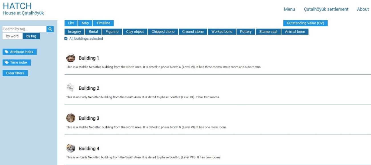
Fig. 1. Hatch: House at Çatalhöyük- home page http://hatch.e-archaeology.org
Buildings are the main type of objects presented within Hatch (Fig. 2). They are used to aggregate a wide range of other categories of objects found at this settlement. These include burials, imagery, figurines, clay objects, chipped stones, ground stones, worked bones, pottery, stamp seals and animal bones. The auxiliary entities used to aggregate different types of objects are special deposits and finds. Each category of objects is described according to a set of predefined attributes. These are divided into two categories: (i) general and (ii) specific. The former comprises chronology, year of discovery, size and textual descriptions. The latter includes the number of rooms, house constructional elements, and decorative motifs, among others. Photographs, drawings, 3D reconstruction (if available) and plans of the subsequent phases of occupation, as distinguished by the excavators, accompany textual data.
Hatch also allows a comprehensive presentation of burials found at the settlement. They are categorized in the form of five burial types, as defined by the deposition of an individual in the burial pit. These include primary, primary disturbed, secondary, tertiary and indeterminate interments. The age of the deceased is described by eight categories. Elaborated burials, characterized by a special treatment of body and/or with rich grave goods, were assigned to the special treatment category. Moreover, a presentation of each individual is supplemented by a comprehensive description of its osteological characteristics and archaeological context. Textual data are accompanied by photographs and drawings (if available) of the skeletons and their burial context.
Presentation of data in Hatch
Hatch presents the data in the form of three intertwined modes: (i) typological, (ii) spatial, and (iii) chronological. The typological mode presents information in the form of a list of objects displayed according to the specified filters. Data in the spatial mode is displayed in the form of GIS objects placed in the scaled cartographic map (based upon Open Street Map). The chronological mode involves presentation of both relative and absolute chronologies. When presenting relative chronology, the objects are tagged by one or more mutually exclusive formats of relative chronology of the settlement. As in a majority of cases, existing chronologies are not yet reliably translated into absolute chronology, buildings from corresponding occupational areas and stages of the settlement development are only presented in the form of relative chronology. Both relative and absolute chronologies are only available for strata featured by TP Phases.
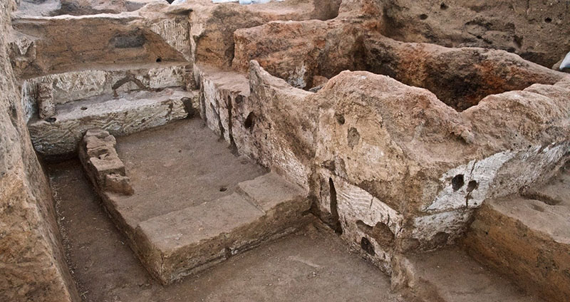
Fig. 2. Late Neolithic Building 122 with walls painted with geometric designs discovered by the Polish team at Çatalhöyük (photo: Jason Quinlan © Çatalhöyük Research Project)
Data can be displayed in a wide range of different formats thanks to the advanced search engine. It operates in two modes: (i) word search and (ii) tag search. The word search facilitates access to the stored data by attributes of a textual type. The tag search makes it possible to search the data by tags attached to the objects as attribute values immersed in the WordNet-based ontology. In both cases, the user can enhance the search by selecting thematically linked tags. The search engine makes it possible to prompt tags semantically linked to the enter word by referring to relations from the ontology. The data stored within Hatch can be displayed in an interactive form. From the typological format of presenting objects, users can go directly to a more detailed presentation of its different aspects. These shall comprise textual data, detailed plans of the buildings and photographs.
Hatch has been produced with the support of the European Commission (through the Culture 2007- 2013 programme) in the framework of the NEARCH Project New scenarios for a community-involved archaeology (Nr 3085/Kultura/2014/2). This publication reflects the views only of the authors, and the Commission cannot be held responsible for any use that may be made of the information contained therein.
References
-
Marciniak, A., 2015. A new perspective on the Central Anatolian Late Neolithic. The TPC Area excavations at Çatalhöyük. In S. R. Steadman & G. McMahon (eds.), The Archaeology of Anatolia. Recent Discoveries (2011-2014), Volume I. Newcastle upon Tyne: Cambridge Scholars Publishing: 6-25.
All visual materials contained on the Hatch website are the property of Çatalhöyük Research Project.
Go back to top